You are here: Home > Network List > TX - Texas Seismological Network Stations List
> Station PB29 Culberson North > Earthquake Result Viewer
PB29 Culberson North - Earthquake Result Viewer
| Earthquake location: |
Southeast Of Loyalty Islands |
| Earthquake latitude/longitude: |
-23.2/170.7 |
| Earthquake time(UTC): |
2023/05/19 (139) 02:57:07 GMT |
| Earthquake Depth: |
10 km |
| Earthquake Magnitude: |
7.7 Mi |
| Earthquake Catalog/Contributor: |
NEIC PDE/at |
|
| Network: |
TX Texas Seismological Network |
| Station: |
PB29 Culberson North |
| Lat/Lon: |
31.75 N/104.51 W |
| Elevation: |
1242 m |
|
| Distance: |
97.7 deg |
| Az: |
58.895 deg |
| Baz: |
247.638 deg |
| Ray Param: |
0.040126733 |
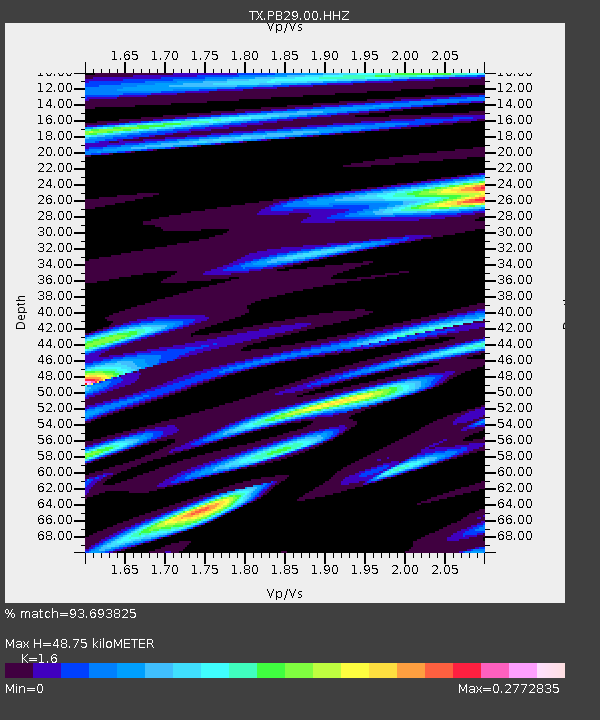
| Estimated Moho Depth: |
48.75 km |
| Estimated Crust Vp/Vs: |
1.60 |
| Assumed Crust Vp: |
6.361 km/s |
| Estimated Crust Vs: |
3.975 km/s |
| Estimated Crust Poisson's Ratio: |
0.18 |
|
| Radial Match: |
93.693825 % |
| Radial Bump: |
363 |
| Transverse Match: |
74.40683 % |
| Transverse Bump: |
400 |
| SOD ConfigId: |
30536071 |
| Insert Time: |
2023-06-02 03:23:19.300 +0000 |
| GWidth: |
2.5 |
| Max Bumps: |
400 |
| Tol: |
0.001 |
|

Signal To Noise
| Channel | StoN | STA | LTA |
| TX:PB29:00:HHZ:20230519T03:10:10.27002Z | 5.2937036 | 2.083526E-6 | 3.9358568E-7 |
| TX:PB29:00:HH1:20230519T03:10:10.27002Z | 2.4427428 | 4.6808793E-7 | 1.9162393E-7 |
| TX:PB29:00:HH2:20230519T03:10:10.27002Z | 2.740847 | 4.930823E-7 | 1.7990143E-7 |
| Arrivals |
| Ps | 4.7 SECOND |
| PpPs | 20 SECOND |
| PsPs/PpSs | 24 SECOND |


