You are here: Home > Network List > TX - Texas Seismological Network Stations List
> Station PB33 CR 111 > Earthquake Result Viewer
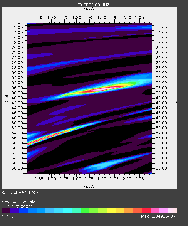
PB33 CR 111 - Earthquake Result Viewer
| Earthquake location: |
Southeast Of Loyalty Islands |
| Earthquake latitude/longitude: |
-23.2/170.7 |
| Earthquake time(UTC): |
2023/05/19 (139) 02:57:07 GMT |
| Earthquake Depth: |
10 km |
| Earthquake Magnitude: |
7.7 Mi |
| Earthquake Catalog/Contributor: |
NEIC PDE/at |
|
| Network: |
TX Texas Seismological Network |
| Station: |
PB33 CR 111 |
| Lat/Lon: |
31.53 N/104.05 W |
| Elevation: |
1006 m |
|
| Distance: |
98.0 deg |
| Az: |
59.248 deg |
| Baz: |
247.83 deg |
| Ray Param: |
0.04003849 |
| Estimated Moho Depth: |
36.25 km |
| Estimated Crust Vp/Vs: |
1.91 |
| Assumed Crust Vp: |
6.361 km/s |
| Estimated Crust Vs: |
3.33 km/s |
| Estimated Crust Poisson's Ratio: |
0.31 |
|
| Radial Match: |
94.42091 % |
| Radial Bump: |
259 |
| Transverse Match: |
87.77024 % |
| Transverse Bump: |
400 |
| SOD ConfigId: |
30536071 |
| Insert Time: |
2023-06-02 03:23:20.354 +0000 |
| GWidth: |
2.5 |
| Max Bumps: |
400 |
| Tol: |
0.001 |
|

Signal To Noise
| Channel | StoN | STA | LTA |
| TX:PB33:00:HHZ:20230519T03:10:11.515015Z | 16.47458 | 2.548468E-7 | 1.5469093E-8 |
| TX:PB33:00:HH1:20230519T03:10:11.515015Z | 1.0774777 | 2.0317339E-8 | 1.8856388E-8 |
| TX:PB33:00:HH2:20230519T03:10:11.515015Z | 7.308764 | 5.96476E-8 | 8.1611065E-9 |
| Arrivals |
| Ps | 5.3 SECOND |
| PpPs | 16 SECOND |
| PsPs/PpSs | 22 SECOND |


