You are here: Home > Network List > UO - University of Oregon Regional Network Stations List
> Station LAIR Myrtle Point, OR, USA > Earthquake Result Viewer
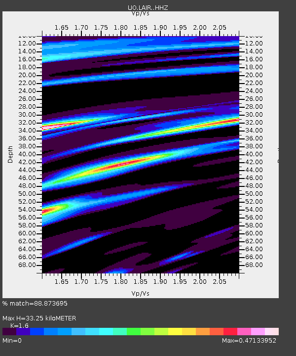
LAIR Myrtle Point, OR, USA - Earthquake Result Viewer
| Earthquake location: |
Southeast Of Loyalty Islands |
| Earthquake latitude/longitude: |
-23.2/170.7 |
| Earthquake time(UTC): |
2023/05/19 (139) 02:57:07 GMT |
| Earthquake Depth: |
10 km |
| Earthquake Magnitude: |
7.7 Mi |
| Earthquake Catalog/Contributor: |
NEIC PDE/at |
|
| Network: |
UO University of Oregon Regional Network |
| Station: |
LAIR Myrtle Point, OR, USA |
| Lat/Lon: |
43.16 N/123.93 W |
| Elevation: |
128 m |
|
| Distance: |
89.2 deg |
| Az: |
41.717 deg |
| Baz: |
236.804 deg |
| Ray Param: |
0.041996326 |
| Estimated Moho Depth: |
33.25 km |
| Estimated Crust Vp/Vs: |
1.60 |
| Assumed Crust Vp: |
6.522 km/s |
| Estimated Crust Vs: |
4.076 km/s |
| Estimated Crust Poisson's Ratio: |
0.18 |
|
| Radial Match: |
88.873695 % |
| Radial Bump: |
400 |
| Transverse Match: |
75.55121 % |
| Transverse Bump: |
400 |
| SOD ConfigId: |
30536071 |
| Insert Time: |
2023-06-02 03:24:05.596 +0000 |
| GWidth: |
2.5 |
| Max Bumps: |
400 |
| Tol: |
0.001 |
|

Signal To Noise
| Channel | StoN | STA | LTA |
| UO:LAIR: :HHZ:20230519T03:09:31.518005Z | 32.39869 | 7.1975537E-6 | 2.2215572E-7 |
| UO:LAIR: :HHN:20230519T03:09:31.518005Z | 4.963772 | 9.060836E-7 | 1.8253934E-7 |
| UO:LAIR: :HHE:20230519T03:09:31.518005Z | 10.492418 | 1.6738551E-6 | 1.5952996E-7 |
| Arrivals |
| Ps | 3.1 SECOND |
| PpPs | 13 SECOND |
| PsPs/PpSs | 16 SECOND |


