You are here: Home > Network List > UO - University of Oregon Regional Network Stations List
> Station VITI Monroe, OR, USA > Earthquake Result Viewer
VITI Monroe, OR, USA - Earthquake Result Viewer
| Earthquake location: |
Southeast Of Loyalty Islands |
| Earthquake latitude/longitude: |
-23.2/170.7 |
| Earthquake time(UTC): |
2023/05/19 (139) 02:57:07 GMT |
| Earthquake Depth: |
10 km |
| Earthquake Magnitude: |
7.7 Mi |
| Earthquake Catalog/Contributor: |
NEIC PDE/at |
|
| Network: |
UO University of Oregon Regional Network |
| Station: |
VITI Monroe, OR, USA |
| Lat/Lon: |
44.28 N/123.32 W |
| Elevation: |
258 m |
|
| Distance: |
90.2 deg |
| Az: |
41.02 deg |
| Baz: |
237.224 deg |
| Ray Param: |
0.04171625 |
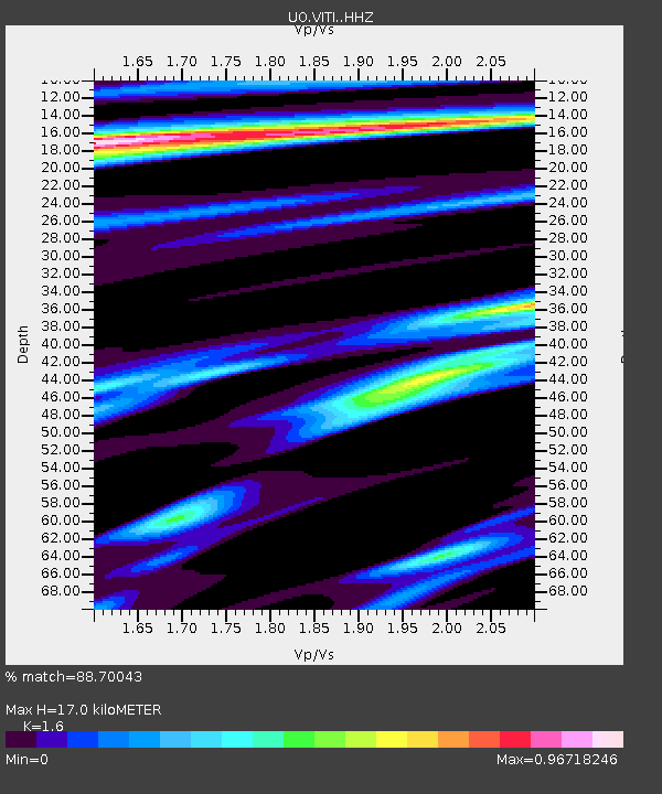
| Estimated Moho Depth: |
17.0 km |
| Estimated Crust Vp/Vs: |
1.60 |
| Assumed Crust Vp: |
6.566 km/s |
| Estimated Crust Vs: |
4.104 km/s |
| Estimated Crust Poisson's Ratio: |
0.18 |
|
| Radial Match: |
88.70043 % |
| Radial Bump: |
400 |
| Transverse Match: |
81.21234 % |
| Transverse Bump: |
400 |
| SOD ConfigId: |
30536071 |
| Insert Time: |
2023-06-02 03:24:51.919 +0000 |
| GWidth: |
2.5 |
| Max Bumps: |
400 |
| Tol: |
0.001 |
|

Signal To Noise
| Channel | StoN | STA | LTA |
| UO:VITI: :HHZ:20230519T03:09:36.070007Z | 34.51569 | 5.832502E-6 | 1.6898119E-7 |
| UO:VITI: :HHN:20230519T03:09:36.070007Z | 6.406758 | 8.9420655E-7 | 1.395724E-7 |
| UO:VITI: :HHE:20230519T03:09:36.070007Z | 10.672927 | 1.3556709E-6 | 1.270196E-7 |
| Arrivals |
| Ps | 1.6 SECOND |
| PpPs | 6.6 SECOND |
| PsPs/PpSs | 8.2 SECOND |


