You are here: Home > Network List > UU - University of Utah Regional Network Stations List
> Station TMU Trail Mountain (BB), UT, USA > Earthquake Result Viewer
TMU Trail Mountain (BB), UT, USA - Earthquake Result Viewer
| Earthquake location: |
Southeast Of Loyalty Islands |
| Earthquake latitude/longitude: |
-23.2/170.7 |
| Earthquake time(UTC): |
2023/05/19 (139) 02:57:07 GMT |
| Earthquake Depth: |
10 km |
| Earthquake Magnitude: |
7.7 Mi |
| Earthquake Catalog/Contributor: |
NEIC PDE/at |
|
| Network: |
UU University of Utah Regional Network |
| Station: |
TMU Trail Mountain (BB), UT, USA |
| Lat/Lon: |
39.30 N/111.21 W |
| Elevation: |
2731 m |
|
| Distance: |
95.8 deg |
| Az: |
49.751 deg |
| Baz: |
244.831 deg |
| Ray Param: |
0.04070792 |
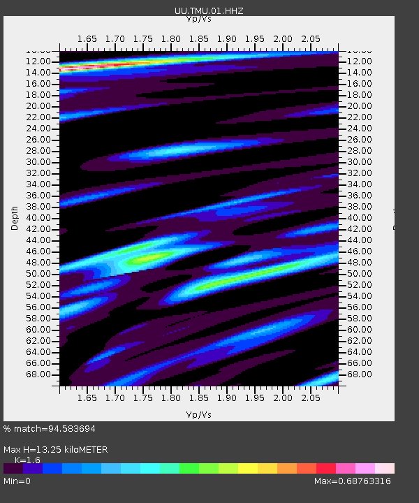
| Estimated Moho Depth: |
13.25 km |
| Estimated Crust Vp/Vs: |
1.60 |
| Assumed Crust Vp: |
6.207 km/s |
| Estimated Crust Vs: |
3.879 km/s |
| Estimated Crust Poisson's Ratio: |
0.18 |
|
| Radial Match: |
94.583694 % |
| Radial Bump: |
400 |
| Transverse Match: |
88.276344 % |
| Transverse Bump: |
400 |
| SOD ConfigId: |
30536071 |
| Insert Time: |
2023-06-02 03:26:15.310 +0000 |
| GWidth: |
2.5 |
| Max Bumps: |
400 |
| Tol: |
0.001 |
|

Signal To Noise
| Channel | StoN | STA | LTA |
| UU:TMU:01:HHZ:20230519T03:10:01.409973Z | 22.713531 | 2.6927883E-6 | 1.1855436E-7 |
| UU:TMU:01:HHN:20230519T03:10:01.409973Z | 2.0998402 | 3.4688594E-7 | 1.6519635E-7 |
| UU:TMU:01:HHE:20230519T03:10:01.409973Z | 10.807693 | 8.856134E-7 | 8.194288E-8 |
| Arrivals |
| Ps | 1.3 SECOND |
| PpPs | 5.4 SECOND |
| PsPs/PpSs | 6.7 SECOND |


