You are here: Home > Network List > UW - Pacific Northwest Regional Seismic Network Stations List
> Station BLOW BLOW, Detroit Lake, OR, USA > Earthquake Result Viewer
BLOW BLOW, Detroit Lake, OR, USA - Earthquake Result Viewer

| Earthquake location: |
Southeast Of Loyalty Islands |
| Earthquake latitude/longitude: |
-23.2/170.7 |
| Earthquake time(UTC): |
2023/05/19 (139) 02:57:07 GMT |
| Earthquake Depth: |
10 km |
| Earthquake Magnitude: |
7.7 Mi |
| Earthquake Catalog/Contributor: |
NEIC PDE/at |
|
| Network: |
UW Pacific Northwest Regional Seismic Network |
| Station: |
BLOW BLOW, Detroit Lake, OR, USA |
| Lat/Lon: |
44.68 N/122.19 W |
| Elevation: |
657 m |
|
| Distance: |
91.1 deg |
| Az: |
41.114 deg |
| Baz: |
238.013 deg |
| Ray Param: |
0.041643493 |
| Estimated Moho Depth: |
65.0 km |
| Estimated Crust Vp/Vs: |
1.78 |
| Assumed Crust Vp: |
6.566 km/s |
| Estimated Crust Vs: |
3.684 km/s |
| Estimated Crust Poisson's Ratio: |
0.27 |
|
| Radial Match: |
90.92716 % |
| Radial Bump: |
400 |
| Transverse Match: |
66.62897 % |
| Transverse Bump: |
400 |
| SOD ConfigId: |
30536071 |
| Insert Time: |
2023-06-02 03:26:35.765 +0000 |
| GWidth: |
2.5 |
| Max Bumps: |
400 |
| Tol: |
0.001 |
|
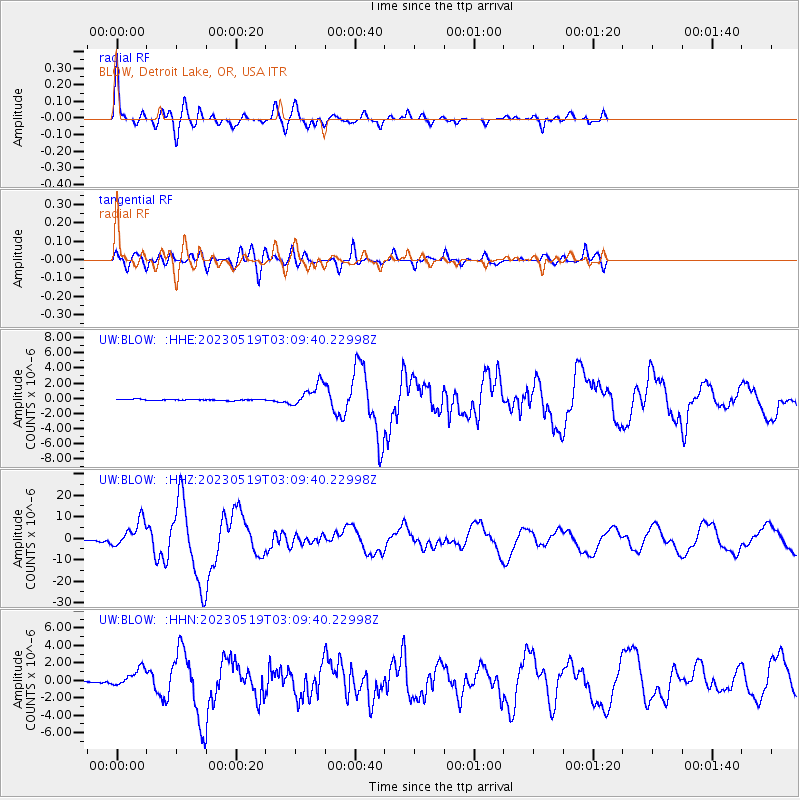
Signal To Noise
| Channel | StoN | STA | LTA |
| UW:BLOW: :HHZ:20230519T03:09:40.22998Z | 45.826527 | 6.217581E-6 | 1.3567646E-7 |
| UW:BLOW: :HHN:20230519T03:09:40.22998Z | 12.354111 | 1.0065015E-6 | 8.147097E-8 |
| UW:BLOW: :HHE:20230519T03:09:40.22998Z | 19.690857 | 1.4566764E-6 | 7.397729E-8 |
| Arrivals |
| Ps | 7.9 SECOND |
| PpPs | 27 SECOND |
| PsPs/PpSs | 35 SECOND |


