You are here: Home > Network List > UW - Pacific Northwest Regional Seismic Network Stations List
> Station DY2 Dyer Hill 2, WA, USA > Earthquake Result Viewer
DY2 Dyer Hill 2, WA, USA - Earthquake Result Viewer
| Earthquake location: |
Southeast Of Loyalty Islands |
| Earthquake latitude/longitude: |
-23.2/170.7 |
| Earthquake time(UTC): |
2023/05/19 (139) 02:57:07 GMT |
| Earthquake Depth: |
10 km |
| Earthquake Magnitude: |
7.7 Mi |
| Earthquake Catalog/Contributor: |
NEIC PDE/at |
|
| Network: |
UW Pacific Northwest Regional Seismic Network |
| Station: |
DY2 Dyer Hill 2, WA, USA |
| Lat/Lon: |
47.99 N/119.77 W |
| Elevation: |
892 m |
|
| Distance: |
94.3 deg |
| Az: |
39.147 deg |
| Baz: |
239.847 deg |
| Ray Param: |
0.041085344 |
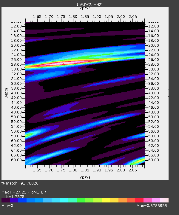
| Estimated Moho Depth: |
27.25 km |
| Estimated Crust Vp/Vs: |
1.76 |
| Assumed Crust Vp: |
6.419 km/s |
| Estimated Crust Vs: |
3.652 km/s |
| Estimated Crust Poisson's Ratio: |
0.26 |
|
| Radial Match: |
91.76026 % |
| Radial Bump: |
400 |
| Transverse Match: |
81.088486 % |
| Transverse Bump: |
400 |
| SOD ConfigId: |
30536071 |
| Insert Time: |
2023-06-02 03:27:13.178 +0000 |
| GWidth: |
2.5 |
| Max Bumps: |
400 |
| Tol: |
0.001 |
|

Signal To Noise
| Channel | StoN | STA | LTA |
| UW:DY2: :HHZ:20230519T03:09:54.650024Z | 38.30421 | 4.3590207E-6 | 1.13800034E-7 |
| UW:DY2: :HHN:20230519T03:09:54.650024Z | 5.349919 | 8.5745637E-7 | 1.6027465E-7 |
| UW:DY2: :HHE:20230519T03:09:54.650024Z | 5.4249754 | 1.1587344E-6 | 2.1359256E-7 |
| Arrivals |
| Ps | 3.3 SECOND |
| PpPs | 11 SECOND |
| PsPs/PpSs | 15 SECOND |


