You are here: Home > Network List > UW - Pacific Northwest Regional Seismic Network Stations List
> Station PRO Prosser, WA, USA (was ISC code PRW) > Earthquake Result Viewer
PRO Prosser, WA, USA (was ISC code PRW) - Earthquake Result Viewer
| Earthquake location: |
Southeast Of Loyalty Islands |
| Earthquake latitude/longitude: |
-23.2/170.7 |
| Earthquake time(UTC): |
2023/05/19 (139) 02:57:07 GMT |
| Earthquake Depth: |
10 km |
| Earthquake Magnitude: |
7.7 Mi |
| Earthquake Catalog/Contributor: |
NEIC PDE/at |
|
| Network: |
UW Pacific Northwest Regional Seismic Network |
| Station: |
PRO Prosser, WA, USA (was ISC code PRW) |
| Lat/Lon: |
46.21 N/119.69 W |
| Elevation: |
553 m |
|
| Distance: |
93.4 deg |
| Az: |
40.713 deg |
| Baz: |
239.804 deg |
| Ray Param: |
0.041270938 |
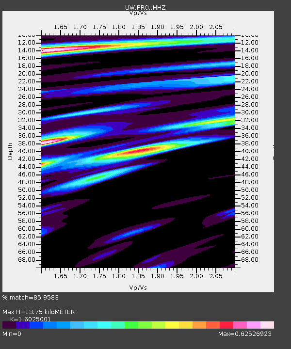
| Estimated Moho Depth: |
13.75 km |
| Estimated Crust Vp/Vs: |
1.60 |
| Assumed Crust Vp: |
6.419 km/s |
| Estimated Crust Vs: |
4.006 km/s |
| Estimated Crust Poisson's Ratio: |
0.18 |
|
| Radial Match: |
85.9583 % |
| Radial Bump: |
400 |
| Transverse Match: |
72.592735 % |
| Transverse Bump: |
400 |
| SOD ConfigId: |
30536071 |
| Insert Time: |
2023-06-02 03:29:06.488 +0000 |
| GWidth: |
2.5 |
| Max Bumps: |
400 |
| Tol: |
0.001 |
|

Signal To Noise
| Channel | StoN | STA | LTA |
| UW:PRO: :HHZ:20230519T03:09:50.799988Z | 33.72073 | 4.9569085E-6 | 1.4699886E-7 |
| UW:PRO: :HHN:20230519T03:09:50.799988Z | 3.4526665 | 5.715889E-7 | 1.6554998E-7 |
| UW:PRO: :HHE:20230519T03:09:50.799988Z | 7.877994 | 1.0372443E-6 | 1.316635E-7 |
| Arrivals |
| Ps | 1.3 SECOND |
| PpPs | 5.5 SECOND |
| PsPs/PpSs | 6.8 SECOND |


