You are here: Home > Network List > UW - Pacific Northwest Regional Seismic Network Stations List
> Station RATT Rattlesnake Lake, King County, WA > Earthquake Result Viewer
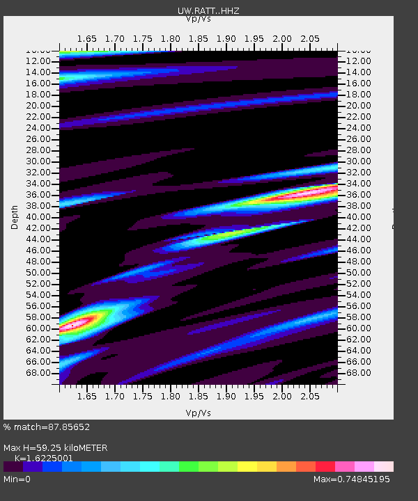
RATT Rattlesnake Lake, King County, WA - Earthquake Result Viewer
| Earthquake location: |
Southeast Of Loyalty Islands |
| Earthquake latitude/longitude: |
-23.2/170.7 |
| Earthquake time(UTC): |
2023/05/19 (139) 02:57:07 GMT |
| Earthquake Depth: |
10 km |
| Earthquake Magnitude: |
7.7 Mi |
| Earthquake Catalog/Contributor: |
NEIC PDE/at |
|
| Network: |
UW Pacific Northwest Regional Seismic Network |
| Station: |
RATT Rattlesnake Lake, King County, WA |
| Lat/Lon: |
47.43 N/121.80 W |
| Elevation: |
442 m |
|
| Distance: |
92.8 deg |
| Az: |
38.923 deg |
| Baz: |
238.363 deg |
| Ray Param: |
0.04139385 |
| Estimated Moho Depth: |
59.25 km |
| Estimated Crust Vp/Vs: |
1.62 |
| Assumed Crust Vp: |
6.597 km/s |
| Estimated Crust Vs: |
4.066 km/s |
| Estimated Crust Poisson's Ratio: |
0.19 |
|
| Radial Match: |
87.85652 % |
| Radial Bump: |
400 |
| Transverse Match: |
89.6219 % |
| Transverse Bump: |
400 |
| SOD ConfigId: |
30536071 |
| Insert Time: |
2023-06-02 03:29:09.656 +0000 |
| GWidth: |
2.5 |
| Max Bumps: |
400 |
| Tol: |
0.001 |
|

Signal To Noise
| Channel | StoN | STA | LTA |
| UW:RATT: :HHZ:20230519T03:09:47.940002Z | 43.167007 | 5.3272865E-6 | 1.2341107E-7 |
| UW:RATT: :HHN:20230519T03:09:47.940002Z | 10.069612 | 1.3636941E-6 | 1.3542667E-7 |
| UW:RATT: :HHE:20230519T03:09:47.940002Z | 8.870176 | 8.745153E-7 | 9.859052E-8 |
| Arrivals |
| Ps | 5.7 SECOND |
| PpPs | 23 SECOND |
| PsPs/PpSs | 29 SECOND |


