You are here: Home > Network List > UW - Pacific Northwest Regional Seismic Network Stations List
> Station RER Emerald Ridge, Mount Rainier, WA, USA > Earthquake Result Viewer
RER Emerald Ridge, Mount Rainier, WA, USA - Earthquake Result Viewer
| Earthquake location: |
Southeast Of Loyalty Islands |
| Earthquake latitude/longitude: |
-23.2/170.7 |
| Earthquake time(UTC): |
2023/05/19 (139) 02:57:07 GMT |
| Earthquake Depth: |
10 km |
| Earthquake Magnitude: |
7.7 Mi |
| Earthquake Catalog/Contributor: |
NEIC PDE/at |
|
| Network: |
UW Pacific Northwest Regional Seismic Network |
| Station: |
RER Emerald Ridge, Mount Rainier, WA, USA |
| Lat/Lon: |
46.82 N/121.84 W |
| Elevation: |
1751 m |
|
| Distance: |
92.5 deg |
| Az: |
39.426 deg |
| Baz: |
238.311 deg |
| Ray Param: |
0.041454908 |
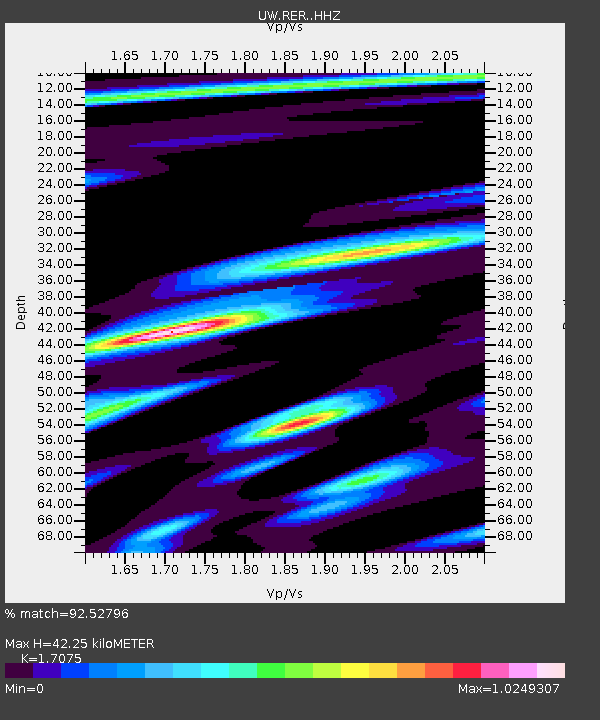
| Estimated Moho Depth: |
42.25 km |
| Estimated Crust Vp/Vs: |
1.71 |
| Assumed Crust Vp: |
6.597 km/s |
| Estimated Crust Vs: |
3.864 km/s |
| Estimated Crust Poisson's Ratio: |
0.24 |
|
| Radial Match: |
92.52796 % |
| Radial Bump: |
400 |
| Transverse Match: |
71.488976 % |
| Transverse Bump: |
400 |
| SOD ConfigId: |
30536071 |
| Insert Time: |
2023-06-02 03:29:12.757 +0000 |
| GWidth: |
2.5 |
| Max Bumps: |
400 |
| Tol: |
0.001 |
|

Signal To Noise
| Channel | StoN | STA | LTA |
| UW:RER: :HHZ:20230519T03:09:46.369995Z | 31.730228 | 4.349634E-6 | 1.370817E-7 |
| UW:RER: :HHN:20230519T03:09:46.369995Z | 8.115117 | 9.117157E-7 | 1.1234781E-7 |
| UW:RER: :HHE:20230519T03:09:46.369995Z | 18.754744 | 1.4940395E-6 | 7.966195E-8 |
| Arrivals |
| Ps | 4.6 SECOND |
| PpPs | 17 SECOND |
| PsPs/PpSs | 22 SECOND |


