You are here: Home > Network List > UW - Pacific Northwest Regional Seismic Network Stations List
> Station TOLE Toledo High School > Earthquake Result Viewer
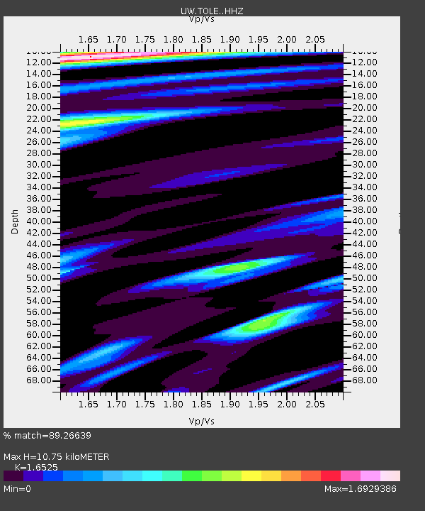
TOLE Toledo High School - Earthquake Result Viewer
| Earthquake location: |
Southeast Of Loyalty Islands |
| Earthquake latitude/longitude: |
-23.2/170.7 |
| Earthquake time(UTC): |
2023/05/19 (139) 02:57:07 GMT |
| Earthquake Depth: |
10 km |
| Earthquake Magnitude: |
7.7 Mi |
| Earthquake Catalog/Contributor: |
NEIC PDE/at |
|
| Network: |
UW Pacific Northwest Regional Seismic Network |
| Station: |
TOLE Toledo High School |
| Lat/Lon: |
46.45 N/122.85 W |
| Elevation: |
85 m |
|
| Distance: |
91.7 deg |
| Az: |
39.37 deg |
| Baz: |
237.586 deg |
| Ray Param: |
0.04157599 |
| Estimated Moho Depth: |
10.75 km |
| Estimated Crust Vp/Vs: |
1.65 |
| Assumed Crust Vp: |
6.566 km/s |
| Estimated Crust Vs: |
3.973 km/s |
| Estimated Crust Poisson's Ratio: |
0.21 |
|
| Radial Match: |
89.26639 % |
| Radial Bump: |
364 |
| Transverse Match: |
82.566376 % |
| Transverse Bump: |
400 |
| SOD ConfigId: |
30536071 |
| Insert Time: |
2023-06-02 03:29:50.063 +0000 |
| GWidth: |
2.5 |
| Max Bumps: |
400 |
| Tol: |
0.001 |
|

Signal To Noise
| Channel | StoN | STA | LTA |
| UW:TOLE: :HHZ:20230519T03:09:42.780029Z | 21.44396 | 5.4176735E-6 | 2.5264333E-7 |
| UW:TOLE: :HHN:20230519T03:09:42.780029Z | 1.911847 | 7.0692306E-7 | 3.6975922E-7 |
| UW:TOLE: :HHE:20230519T03:09:42.780029Z | 3.5788856 | 9.1625793E-7 | 2.5601767E-7 |
| Arrivals |
| Ps | 1.1 SECOND |
| PpPs | 4.2 SECOND |
| PsPs/PpSs | 5.3 SECOND |


