You are here: Home > Network List > UW - Pacific Northwest Regional Seismic Network Stations List
> Station TREE Summer Lake, OR, USA > Earthquake Result Viewer
TREE Summer Lake, OR, USA - Earthquake Result Viewer
| Earthquake location: |
Southeast Of Loyalty Islands |
| Earthquake latitude/longitude: |
-23.2/170.7 |
| Earthquake time(UTC): |
2023/05/19 (139) 02:57:07 GMT |
| Earthquake Depth: |
10 km |
| Earthquake Magnitude: |
7.7 Mi |
| Earthquake Catalog/Contributor: |
NEIC PDE/at |
|
| Network: |
UW Pacific Northwest Regional Seismic Network |
| Station: |
TREE Summer Lake, OR, USA |
| Lat/Lon: |
42.73 N/120.89 W |
| Elevation: |
1881 m |
|
| Distance: |
90.9 deg |
| Az: |
43.273 deg |
| Baz: |
238.865 deg |
| Ray Param: |
0.041666377 |
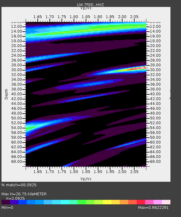
| Estimated Moho Depth: |
28.75 km |
| Estimated Crust Vp/Vs: |
2.09 |
| Assumed Crust Vp: |
6.597 km/s |
| Estimated Crust Vs: |
3.153 km/s |
| Estimated Crust Poisson's Ratio: |
0.35 |
|
| Radial Match: |
88.0925 % |
| Radial Bump: |
400 |
| Transverse Match: |
87.2512 % |
| Transverse Bump: |
400 |
| SOD ConfigId: |
30536071 |
| Insert Time: |
2023-06-02 03:29:55.664 +0000 |
| GWidth: |
2.5 |
| Max Bumps: |
400 |
| Tol: |
0.001 |
|

Signal To Noise
| Channel | StoN | STA | LTA |
| UW:TREE: :HHZ:20230519T03:09:39.190002Z | 25.69317 | 4.9240707E-6 | 1.9164901E-7 |
| UW:TREE: :HHN:20230519T03:09:39.190002Z | 3.419926 | 6.875456E-7 | 2.0104108E-7 |
| UW:TREE: :HHE:20230519T03:09:39.190002Z | 10.154477 | 1.437703E-6 | 1.4158316E-7 |
| Arrivals |
| Ps | 4.8 SECOND |
| PpPs | 13 SECOND |
| PsPs/PpSs | 18 SECOND |


