You are here: Home > Network List > UW - Pacific Northwest Regional Seismic Network Stations List
> Station TWISP Winthrop, WA, USA > Earthquake Result Viewer
TWISP Winthrop, WA, USA - Earthquake Result Viewer
| Earthquake location: |
Southeast Of Loyalty Islands |
| Earthquake latitude/longitude: |
-23.2/170.7 |
| Earthquake time(UTC): |
2023/05/19 (139) 02:57:07 GMT |
| Earthquake Depth: |
10 km |
| Earthquake Magnitude: |
7.7 Mi |
| Earthquake Catalog/Contributor: |
NEIC PDE/at |
|
| Network: |
UW Pacific Northwest Regional Seismic Network |
| Station: |
TWISP Winthrop, WA, USA |
| Lat/Lon: |
48.46 N/120.12 W |
| Elevation: |
756 m |
|
| Distance: |
94.3 deg |
| Az: |
38.617 deg |
| Baz: |
239.628 deg |
| Ray Param: |
0.041076146 |
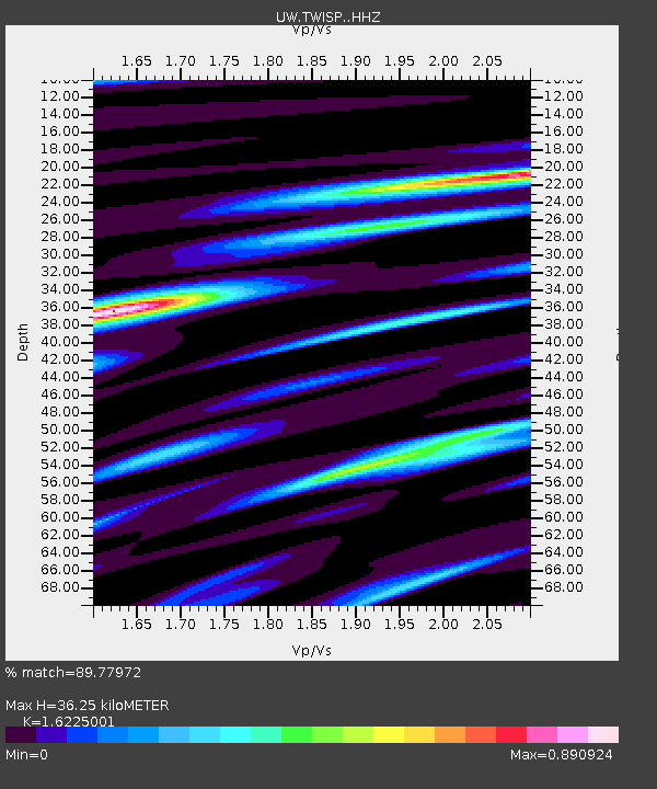
| Estimated Moho Depth: |
36.25 km |
| Estimated Crust Vp/Vs: |
1.62 |
| Assumed Crust Vp: |
6.566 km/s |
| Estimated Crust Vs: |
4.047 km/s |
| Estimated Crust Poisson's Ratio: |
0.19 |
|
| Radial Match: |
89.77972 % |
| Radial Bump: |
400 |
| Transverse Match: |
76.52605 % |
| Transverse Bump: |
400 |
| SOD ConfigId: |
30536071 |
| Insert Time: |
2023-06-02 03:29:59.348 +0000 |
| GWidth: |
2.5 |
| Max Bumps: |
400 |
| Tol: |
0.001 |
|

Signal To Noise
| Channel | StoN | STA | LTA |
| UW:TWISP: :HHZ:20230519T03:09:54.830017Z | 25.282194 | 4.2166726E-6 | 1.6678428E-7 |
| UW:TWISP: :HHN:20230519T03:09:54.830017Z | 9.906196 | 6.353542E-7 | 6.413705E-8 |
| UW:TWISP: :HHE:20230519T03:09:54.830017Z | 14.445406 | 8.72948E-7 | 6.043084E-8 |
| Arrivals |
| Ps | 3.5 SECOND |
| PpPs | 14 SECOND |
| PsPs/PpSs | 18 SECOND |


