You are here: Home > Network List > UW - Pacific Northwest Regional Seismic Network Stations List
> Station WAT2 Waterville, WA, USA > Earthquake Result Viewer
WAT2 Waterville, WA, USA - Earthquake Result Viewer
| Earthquake location: |
Southeast Of Loyalty Islands |
| Earthquake latitude/longitude: |
-23.2/170.7 |
| Earthquake time(UTC): |
2023/05/19 (139) 02:57:07 GMT |
| Earthquake Depth: |
10 km |
| Earthquake Magnitude: |
7.7 Mi |
| Earthquake Catalog/Contributor: |
NEIC PDE/at |
|
| Network: |
UW Pacific Northwest Regional Seismic Network |
| Station: |
WAT2 Waterville, WA, USA |
| Lat/Lon: |
47.62 N/120.11 W |
| Elevation: |
875 m |
|
| Distance: |
93.9 deg |
| Az: |
39.347 deg |
| Baz: |
239.58 deg |
| Ray Param: |
0.04117227 |
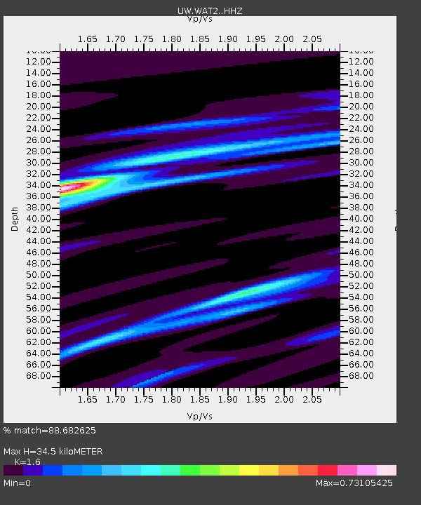
| Estimated Moho Depth: |
34.5 km |
| Estimated Crust Vp/Vs: |
1.60 |
| Assumed Crust Vp: |
6.597 km/s |
| Estimated Crust Vs: |
4.123 km/s |
| Estimated Crust Poisson's Ratio: |
0.18 |
|
| Radial Match: |
88.682625 % |
| Radial Bump: |
400 |
| Transverse Match: |
87.16284 % |
| Transverse Bump: |
400 |
| SOD ConfigId: |
30536071 |
| Insert Time: |
2023-06-02 03:30:06.791 +0000 |
| GWidth: |
2.5 |
| Max Bumps: |
400 |
| Tol: |
0.001 |
|

Signal To Noise
| Channel | StoN | STA | LTA |
| UW:WAT2: :HHZ:20230519T03:09:52.900024Z | 35.599335 | 4.459985E-6 | 1.2528282E-7 |
| UW:WAT2: :HHN:20230519T03:09:52.900024Z | 6.648201 | 5.8178233E-7 | 8.750973E-8 |
| UW:WAT2: :HHE:20230519T03:09:52.900024Z | 9.463882 | 1.0326055E-6 | 1.0911013E-7 |
| Arrivals |
| Ps | 3.2 SECOND |
| PpPs | 13 SECOND |
| PsPs/PpSs | 16 SECOND |


