You are here: Home > Network List > WW - Idaho Seismic Network () Stations List
> Station TYLR Tyler Ranch Idaho > Earthquake Result Viewer
TYLR Tyler Ranch Idaho - Earthquake Result Viewer
| Earthquake location: |
Southeast Of Loyalty Islands |
| Earthquake latitude/longitude: |
-23.2/170.7 |
| Earthquake time(UTC): |
2023/05/19 (139) 02:57:07 GMT |
| Earthquake Depth: |
10 km |
| Earthquake Magnitude: |
7.7 Mi |
| Earthquake Catalog/Contributor: |
NEIC PDE/at |
|
| Network: |
WW Idaho Seismic Network () |
| Station: |
TYLR Tyler Ranch Idaho |
| Lat/Lon: |
45.10 N/114.85 W |
| Elevation: |
1203 m |
|
| Distance: |
95.9 deg |
| Az: |
43.318 deg |
| Baz: |
243.041 deg |
| Ray Param: |
0.040676314 |
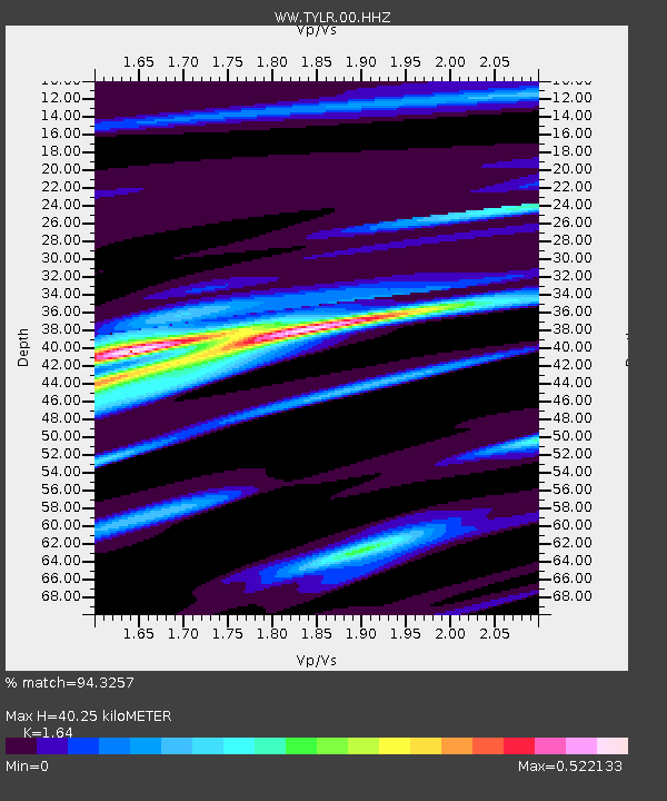
| Estimated Moho Depth: |
40.25 km |
| Estimated Crust Vp/Vs: |
1.64 |
| Assumed Crust Vp: |
6.577 km/s |
| Estimated Crust Vs: |
4.01 km/s |
| Estimated Crust Poisson's Ratio: |
0.20 |
|
| Radial Match: |
94.3257 % |
| Radial Bump: |
400 |
| Transverse Match: |
92.62771 % |
| Transverse Bump: |
400 |
| SOD ConfigId: |
30536071 |
| Insert Time: |
2023-06-02 03:30:37.478 +0000 |
| GWidth: |
2.5 |
| Max Bumps: |
400 |
| Tol: |
0.001 |
|
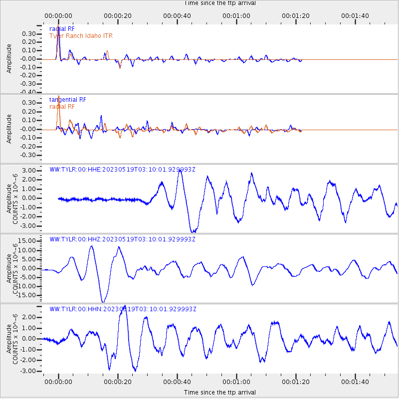
Signal To Noise
| Channel | StoN | STA | LTA |
| WW:TYLR:00:HHZ:20230519T03:10:01.929993Z | 22.936947 | 3.4057025E-6 | 1.4848108E-7 |
| WW:TYLR:00:HHN:20230519T03:10:01.929993Z | 2.867859 | 4.5320948E-7 | 1.5803062E-7 |
| WW:TYLR:00:HHE:20230519T03:10:01.929993Z | 10.413275 | 7.8137765E-7 | 7.503669E-8 |
| Arrivals |
| Ps | 4.0 SECOND |
| PpPs | 16 SECOND |
| PsPs/PpSs | 20 SECOND |


