You are here: Home > Network List > C8 - Canadian Seismic Research Network () Stations List
> Station GRIB Gribbell Island, BC, CA > Earthquake Result Viewer
GRIB Gribbell Island, BC, CA - Earthquake Result Viewer
| Earthquake location: |
Southeast Of Loyalty Islands |
| Earthquake latitude/longitude: |
-23.3/170.4 |
| Earthquake time(UTC): |
2023/05/19 (139) 03:10:44 GMT |
| Earthquake Depth: |
19 km |
| Earthquake Magnitude: |
5.7 mb |
| Earthquake Catalog/Contributor: |
NEIC PDE/us |
|
| Network: |
C8 Canadian Seismic Research Network () |
| Station: |
GRIB Gribbell Island, BC, CA |
| Lat/Lon: |
53.34 N/129.14 W |
| Elevation: |
418 m |
|
| Distance: |
92.5 deg |
| Az: |
31.464 deg |
| Baz: |
233.132 deg |
| Ray Param: |
0.041449063 |
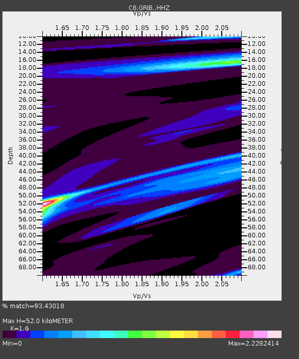
| Estimated Moho Depth: |
52.0 km |
| Estimated Crust Vp/Vs: |
1.60 |
| Assumed Crust Vp: |
6.545 km/s |
| Estimated Crust Vs: |
4.091 km/s |
| Estimated Crust Poisson's Ratio: |
0.18 |
|
| Radial Match: |
93.43018 % |
| Radial Bump: |
221 |
| Transverse Match: |
93.47165 % |
| Transverse Bump: |
250 |
| SOD ConfigId: |
30536071 |
| Insert Time: |
2023-06-02 04:06:52.775 +0000 |
| GWidth: |
2.5 |
| Max Bumps: |
400 |
| Tol: |
0.001 |
|
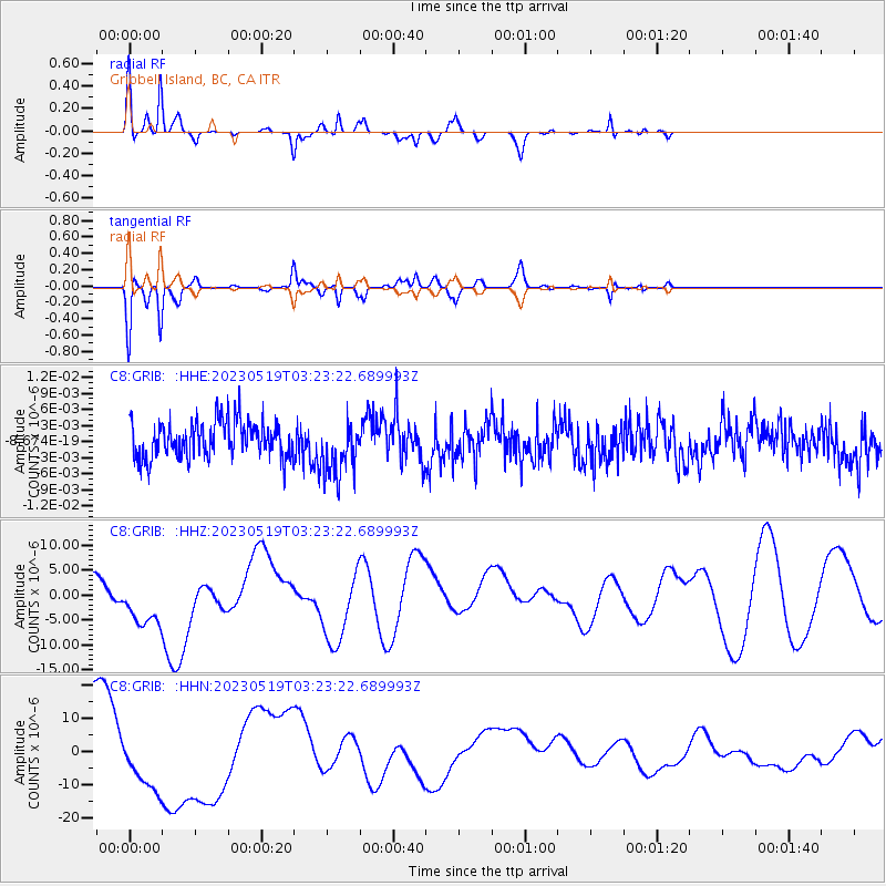
Signal To Noise
| Channel | StoN | STA | LTA |
| C8:GRIB: :HHZ:20230519T03:23:22.689993Z | 0.49206227 | 5.048728E-6 | 1.02603435E-5 |
| C8:GRIB: :HHN:20230519T03:23:22.689993Z | 0.53665656 | 8.316131E-6 | 1.5496189E-5 |
| C8:GRIB: :HHE:20230519T03:23:22.689993Z | 1.6008366 | 5.36617E-9 | 3.3521035E-9 |
| Arrivals |
| Ps | 4.9 SECOND |
| PpPs | 20 SECOND |
| PsPs/PpSs | 25 SECOND |


