You are here: Home > Network List > UW - Pacific Northwest Regional Seismic Network Stations List
> Station IRON Crane, OR, USA > Earthquake Result Viewer
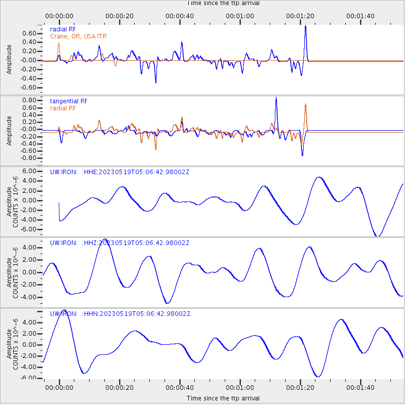
IRON Crane, OR, USA - Earthquake Result Viewer
*The percent match for this event was below the threshold and hence no stack was calculated.
| Earthquake location: |
Southeast Of Loyalty Islands |
| Earthquake latitude/longitude: |
-23.2/170.5 |
| Earthquake time(UTC): |
2023/05/19 (139) 04:54:04 GMT |
| Earthquake Depth: |
28 km |
| Earthquake Magnitude: |
5.5 mb |
| Earthquake Catalog/Contributor: |
NEIC PDE/us |
|
| Network: |
UW Pacific Northwest Regional Seismic Network |
| Station: |
IRON Crane, OR, USA |
| Lat/Lon: |
43.36 N/118.47 W |
| Elevation: |
1226 m |
|
| Distance: |
92.9 deg |
| Az: |
43.683 deg |
| Baz: |
240.574 deg |
| Ray Param: |
$rayparam |
*The percent match for this event was below the threshold and hence was not used in the summary stack. |
|
| Radial Match: |
78.261284 % |
| Radial Bump: |
400 |
| Transverse Match: |
69.390686 % |
| Transverse Bump: |
400 |
| SOD ConfigId: |
30536071 |
| Insert Time: |
2023-06-02 05:09:17.024 +0000 |
| GWidth: |
2.5 |
| Max Bumps: |
400 |
| Tol: |
0.001 |
|
Signal To Noise
| Channel | StoN | STA | LTA |
| UW:IRON: :HHZ:20230519T05:06:42.98002Z | 2.25396 | 3.0997985E-6 | 1.3752677E-6 |
| UW:IRON: :HHN:20230519T05:06:42.98002Z | 2.061868 | 5.367231E-6 | 2.6030916E-6 |
| UW:IRON: :HHE:20230519T05:06:42.98002Z | 0.77284247 | 1.4286228E-6 | 1.8485304E-6 |
| Arrivals |
| Ps | |
| PpPs | |
| PsPs/PpSs | |


