You are here: Home > Network List > TA - USArray Transportable Network (new EarthScope stations) Stations List
> Station L02D Cave Junction, OR, USA > Earthquake Result Viewer
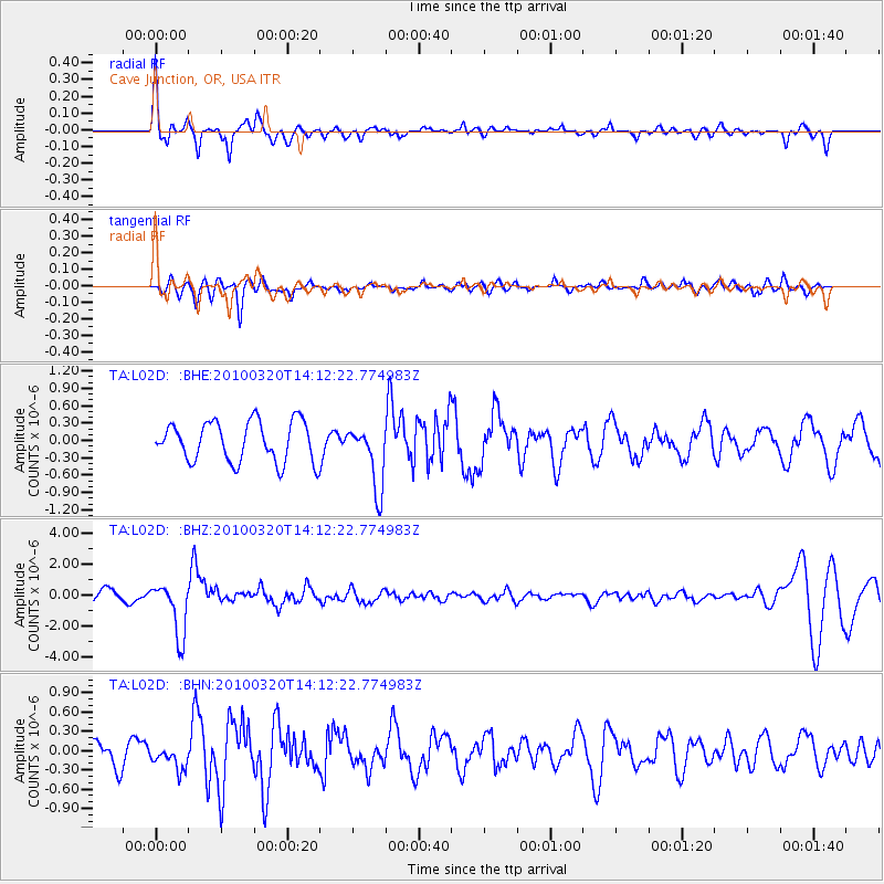
L02D Cave Junction, OR, USA - Earthquake Result Viewer
*The percent match for this event was below the threshold and hence no stack was calculated.
| Earthquake location: |
New Ireland Region, P.N.G. |
| Earthquake latitude/longitude: |
-3.4/152.2 |
| Earthquake time(UTC): |
2010/03/20 (079) 14:00:49 GMT |
| Earthquake Depth: |
415 km |
| Earthquake Magnitude: |
6.0 MB, 6.6 MW, 6.5 MW |
| Earthquake Catalog/Contributor: |
WHDF/NEIC |
|
| Network: |
TA USArray Transportable Network (new EarthScope stations) |
| Station: |
L02D Cave Junction, OR, USA |
| Lat/Lon: |
42.16 N/123.60 W |
| Elevation: |
458 m |
|
| Distance: |
87.9 deg |
| Az: |
47.746 deg |
| Baz: |
263.604 deg |
| Ray Param: |
$rayparam |
*The percent match for this event was below the threshold and hence was not used in the summary stack. |
|
| Radial Match: |
78.15699 % |
| Radial Bump: |
374 |
| Transverse Match: |
64.7012 % |
| Transverse Bump: |
400 |
| SOD ConfigId: |
308276 |
| Insert Time: |
2010-06-22 21:45:45.587 +0000 |
| GWidth: |
2.5 |
| Max Bumps: |
400 |
| Tol: |
0.001 |
|
Signal To Noise
| Channel | StoN | STA | LTA |
| TA:L02D: :BHZ:20100320T14:12:22.774983Z | 5.4339085 | 1.7571077E-6 | 3.233598E-7 |
| TA:L02D: :BHN:20100320T14:12:22.774983Z | 0.82477164 | 1.7842032E-7 | 2.1632694E-7 |
| TA:L02D: :BHE:20100320T14:12:22.774983Z | 1.5986067 | 5.5411135E-7 | 3.4662145E-7 |
| Arrivals |
| Ps | |
| PpPs | |
| PsPs/PpSs | |


