You are here: Home > Network List > US - United States National Seismic Network Stations List
> Station NEW Newport, Washington, USA > Earthquake Result Viewer
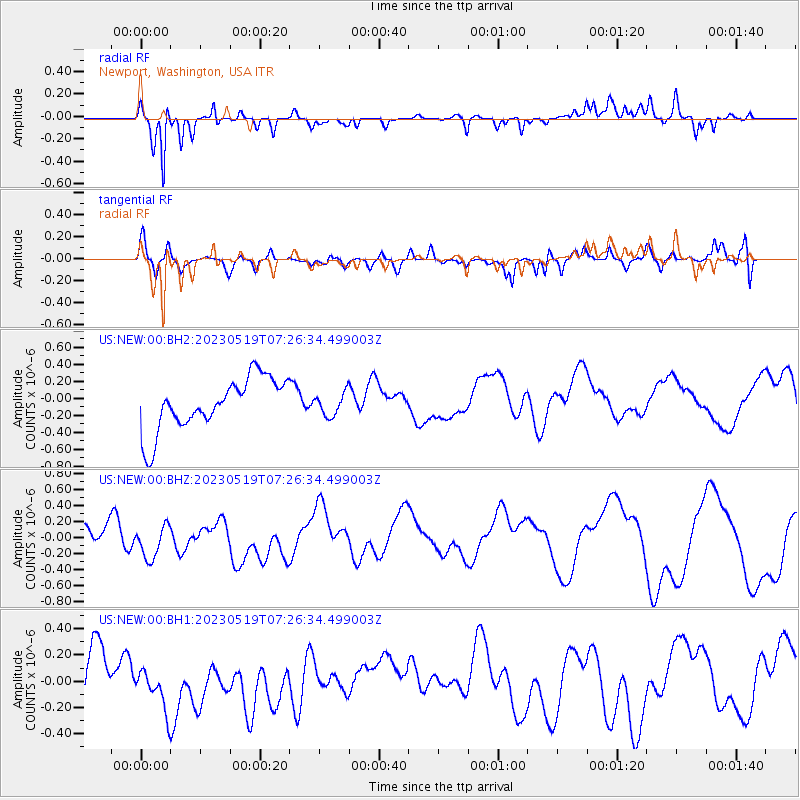
NEW Newport, Washington, USA - Earthquake Result Viewer
*The percent match for this event was below the threshold and hence no stack was calculated.
| Earthquake location: |
Southeast Of Loyalty Islands |
| Earthquake latitude/longitude: |
-23.2/170.8 |
| Earthquake time(UTC): |
2023/05/19 (139) 07:13:39 GMT |
| Earthquake Depth: |
10 km |
| Earthquake Magnitude: |
5.5 mb |
| Earthquake Catalog/Contributor: |
NEIC PDE/us |
|
| Network: |
US United States National Seismic Network |
| Station: |
NEW Newport, Washington, USA |
| Lat/Lon: |
48.26 N/117.12 W |
| Elevation: |
760 m |
|
| Distance: |
95.9 deg |
| Az: |
39.738 deg |
| Baz: |
241.688 deg |
| Ray Param: |
$rayparam |
*The percent match for this event was below the threshold and hence was not used in the summary stack. |
|
| Radial Match: |
77.47971 % |
| Radial Bump: |
305 |
| Transverse Match: |
65.807915 % |
| Transverse Bump: |
400 |
| SOD ConfigId: |
30536071 |
| Insert Time: |
2023-06-02 07:29:48.604 +0000 |
| GWidth: |
2.5 |
| Max Bumps: |
400 |
| Tol: |
0.001 |
|
Signal To Noise
| Channel | StoN | STA | LTA |
| US:NEW:00:BHZ:20230519T07:26:34.499003Z | 1.6085368 | 2.3516401E-7 | 1.4619746E-7 |
| US:NEW:00:BH1:20230519T07:26:34.499003Z | 1.0415127 | 1.6725546E-7 | 1.6058898E-7 |
| US:NEW:00:BH2:20230519T07:26:34.499003Z | 0.43020898 | 1.3210531E-7 | 3.070724E-7 |
| Arrivals |
| Ps | |
| PpPs | |
| PsPs/PpSs | |


