You are here: Home > Network List > UW - Pacific Northwest Regional Seismic Network Stations List
> Station MRBL Marblemount, WA, USA > Earthquake Result Viewer
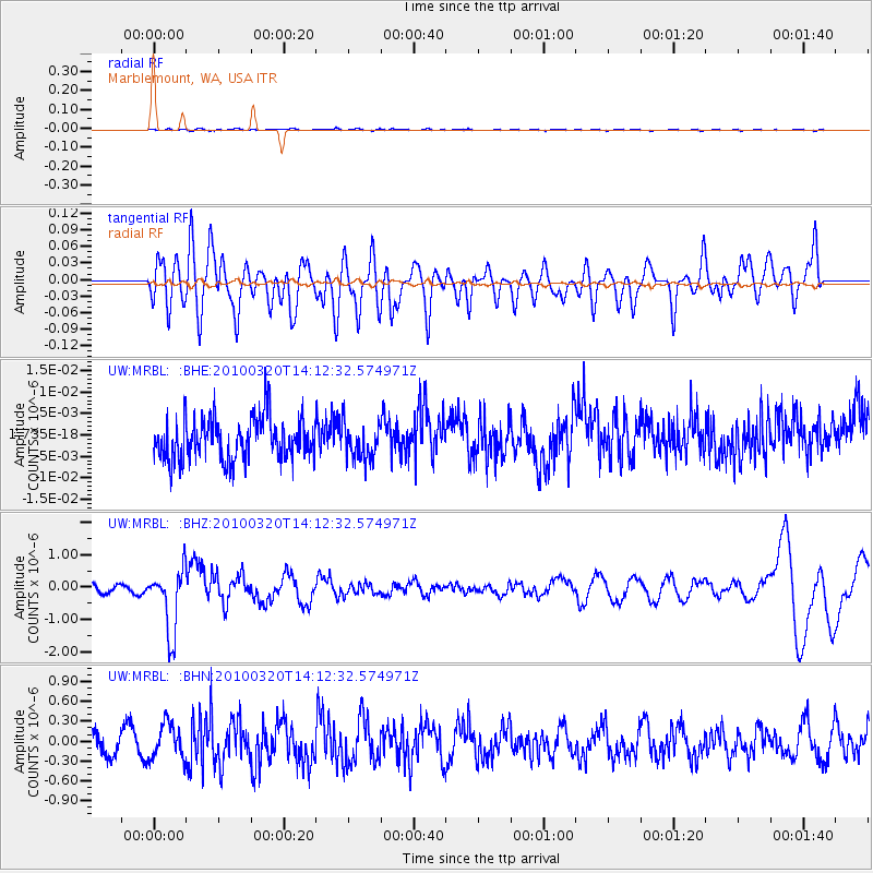
MRBL Marblemount, WA, USA - Earthquake Result Viewer
*The percent match for this event was below the threshold and hence no stack was calculated.
| Earthquake location: |
New Ireland Region, P.N.G. |
| Earthquake latitude/longitude: |
-3.4/152.2 |
| Earthquake time(UTC): |
2010/03/20 (079) 14:00:49 GMT |
| Earthquake Depth: |
415 km |
| Earthquake Magnitude: |
6.0 MB, 6.6 MW, 6.5 MW |
| Earthquake Catalog/Contributor: |
WHDF/NEIC |
|
| Network: |
UW Pacific Northwest Regional Seismic Network |
| Station: |
MRBL Marblemount, WA, USA |
| Lat/Lon: |
48.52 N/121.48 W |
| Elevation: |
75 m |
|
| Distance: |
90.0 deg |
| Az: |
41.565 deg |
| Baz: |
264.996 deg |
| Ray Param: |
$rayparam |
*The percent match for this event was below the threshold and hence was not used in the summary stack. |
|
| Radial Match: |
52.532143 % |
| Radial Bump: |
400 |
| Transverse Match: |
53.19676 % |
| Transverse Bump: |
400 |
| SOD ConfigId: |
308276 |
| Insert Time: |
2010-06-22 21:47:59.919 +0000 |
| GWidth: |
2.5 |
| Max Bumps: |
400 |
| Tol: |
0.001 |
|
Signal To Noise
| Channel | StoN | STA | LTA |
| UW:MRBL: :BHZ:20100320T14:12:32.574971Z | 7.069936 | 9.809239E-7 | 1.387458E-7 |
| UW:MRBL: :BHN:20100320T14:12:32.574971Z | 1.4790365 | 2.6235443E-7 | 1.77382E-7 |
| UW:MRBL: :BHE:20100320T14:12:32.574971Z | 0.8424766 | 4.1013237E-9 | 4.868175E-9 |
| Arrivals |
| Ps | |
| PpPs | |
| PsPs/PpSs | |


