You are here: Home > Network List > UW - Pacific Northwest Regional Seismic Network Stations List
> Station UMAT Pilot Rock, OR, USA > Earthquake Result Viewer
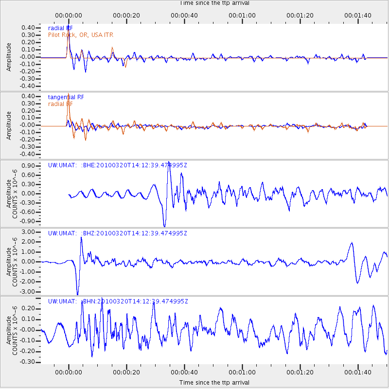
UMAT Pilot Rock, OR, USA - Earthquake Result Viewer
*The percent match for this event was below the threshold and hence no stack was calculated.
| Earthquake location: |
New Ireland Region, P.N.G. |
| Earthquake latitude/longitude: |
-3.4/152.2 |
| Earthquake time(UTC): |
2010/03/20 (079) 14:00:49 GMT |
| Earthquake Depth: |
415 km |
| Earthquake Magnitude: |
6.0 MB, 6.6 MW, 6.5 MW |
| Earthquake Catalog/Contributor: |
WHDF/NEIC |
|
| Network: |
UW Pacific Northwest Regional Seismic Network |
| Station: |
UMAT Pilot Rock, OR, USA |
| Lat/Lon: |
45.29 N/118.96 W |
| Elevation: |
1318 m |
|
| Distance: |
91.5 deg |
| Az: |
44.909 deg |
| Baz: |
266.79 deg |
| Ray Param: |
$rayparam |
*The percent match for this event was below the threshold and hence was not used in the summary stack. |
|
| Radial Match: |
77.95383 % |
| Radial Bump: |
246 |
| Transverse Match: |
51.34011 % |
| Transverse Bump: |
400 |
| SOD ConfigId: |
308276 |
| Insert Time: |
2010-06-22 21:48:16.049 +0000 |
| GWidth: |
2.5 |
| Max Bumps: |
400 |
| Tol: |
0.001 |
|
Signal To Noise
| Channel | StoN | STA | LTA |
| UW:UMAT: :BHZ:20100320T14:12:39.474995Z | 11.42323 | 1.4251011E-6 | 1.2475466E-7 |
| UW:UMAT: :BHN:20100320T14:12:39.474995Z | 2.4672494 | 1.2474722E-7 | 5.056125E-8 |
| UW:UMAT: :BHE:20100320T14:12:39.474995Z | 7.686306 | 5.687001E-7 | 7.398874E-8 |
| Arrivals |
| Ps | |
| PpPs | |
| PsPs/PpSs | |


