You are here: Home > Network List > TM - Thai Seismic Monitoring Network Stations List
> Station CHBT Khereethan Dam, Chanthaburi > Earthquake Result Viewer
CHBT Khereethan Dam, Chanthaburi - Earthquake Result Viewer
| Earthquake location: |
Eastern Gulf Of Aden |
| Earthquake latitude/longitude: |
12.8/49.2 |
| Earthquake time(UTC): |
2023/05/19 (139) 15:15:03 GMT |
| Earthquake Depth: |
10 km |
| Earthquake Magnitude: |
5.7 mwb |
| Earthquake Catalog/Contributor: |
NEIC PDE/us |
|
| Network: |
TM Thai Seismic Monitoring Network |
| Station: |
CHBT Khereethan Dam, Chanthaburi |
| Lat/Lon: |
12.74 N/102.35 E |
| Elevation: |
198 m |
|
| Distance: |
51.7 deg |
| Az: |
83.76 deg |
| Baz: |
276.279 deg |
| Ray Param: |
0.067220174 |
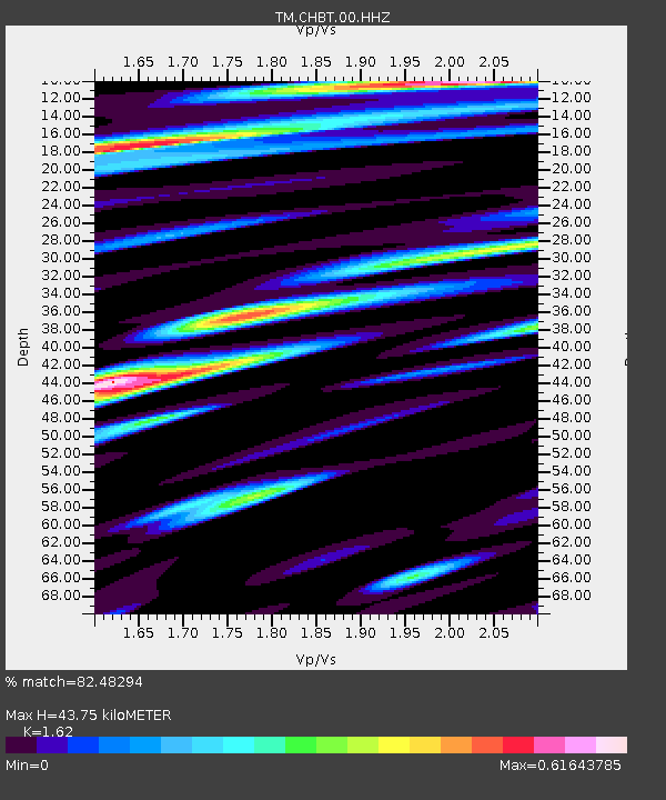
| Estimated Moho Depth: |
43.75 km |
| Estimated Crust Vp/Vs: |
1.62 |
| Assumed Crust Vp: |
6.498 km/s |
| Estimated Crust Vs: |
4.011 km/s |
| Estimated Crust Poisson's Ratio: |
0.19 |
|
| Radial Match: |
82.48294 % |
| Radial Bump: |
340 |
| Transverse Match: |
38.27491 % |
| Transverse Bump: |
400 |
| SOD ConfigId: |
30536071 |
| Insert Time: |
2023-06-02 15:23:44.959 +0000 |
| GWidth: |
2.5 |
| Max Bumps: |
400 |
| Tol: |
0.001 |
|

Signal To Noise
| Channel | StoN | STA | LTA |
| TM:CHBT:00:HHZ:20230519T15:23:39.620022Z | 3.8370476 | 3.067478E-7 | 7.994371E-8 |
| TM:CHBT:00:HHN:20230519T15:23:39.620022Z | 1.5072267 | 2.1783592E-7 | 1.4452765E-7 |
| TM:CHBT:00:HHE:20230519T15:23:39.620022Z | 2.2351487 | 2.1509028E-7 | 9.6230856E-8 |
| Arrivals |
| Ps | 4.4 SECOND |
| PpPs | 17 SECOND |
| PsPs/PpSs | 21 SECOND |


