You are here: Home > Network List > 1E - GSC-BCOGC Induced Seismicity Study Stations List
> Station MONT9 Z > Earthquake Result Viewer
MONT9 Z - Earthquake Result Viewer
| Earthquake location: |
Southeast Of Loyalty Islands |
| Earthquake latitude/longitude: |
-23.1/170.4 |
| Earthquake time(UTC): |
2023/05/20 (140) 01:51:01 GMT |
| Earthquake Depth: |
45 km |
| Earthquake Magnitude: |
7.4 Mi |
| Earthquake Catalog/Contributor: |
NEIC PDE/at |
|
| Network: |
1E GSC-BCOGC Induced Seismicity Study |
| Station: |
MONT9 Z |
| Lat/Lon: |
55.80 N/120.54 W |
| Elevation: |
832 m |
|
| Distance: |
97.8 deg |
| Az: |
32.16 deg |
| Baz: |
240.233 deg |
| Ray Param: |
0.04006813 |
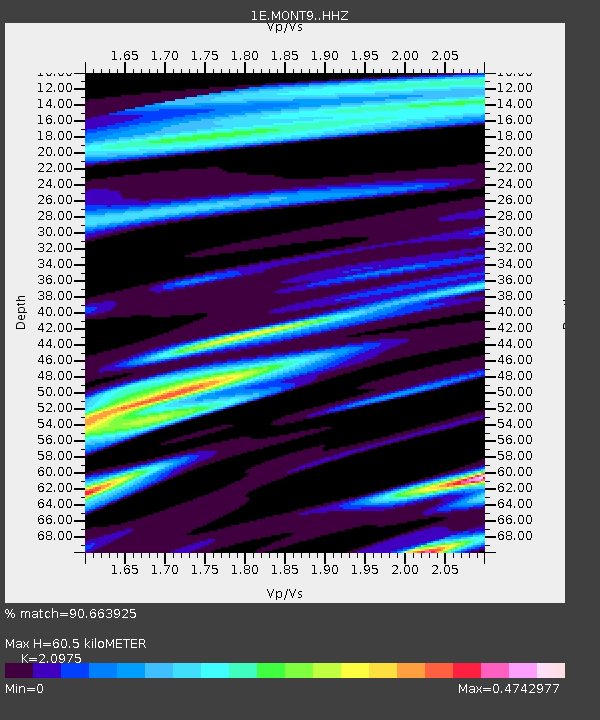
| Estimated Moho Depth: |
60.5 km |
| Estimated Crust Vp/Vs: |
2.10 |
| Assumed Crust Vp: |
6.303 km/s |
| Estimated Crust Vs: |
3.005 km/s |
| Estimated Crust Poisson's Ratio: |
0.35 |
|
| Radial Match: |
90.663925 % |
| Radial Bump: |
400 |
| Transverse Match: |
51.920986 % |
| Transverse Bump: |
400 |
| SOD ConfigId: |
30536071 |
| Insert Time: |
2023-06-03 01:51:57.462 +0000 |
| GWidth: |
2.5 |
| Max Bumps: |
400 |
| Tol: |
0.001 |
|

Signal To Noise
| Channel | StoN | STA | LTA |
| 1E:MONT9: :HHZ:20230520T02:04:00.130005Z | 3.2633975 | 6.148132E-7 | 1.8839667E-7 |
| 1E:MONT9: :HHN:20230520T02:04:00.130005Z | 0.8284439 | 3.8082186E-7 | 4.5968335E-7 |
| 1E:MONT9: :HHE:20230520T02:04:00.130005Z | 0.60226965 | 2.1138648E-7 | 3.509831E-7 |
| Arrivals |
| Ps | 11 SECOND |
| PpPs | 29 SECOND |
| PsPs/PpSs | 40 SECOND |


