You are here: Home > Network List > AK - Alaska Regional Network Stations List
> Station BPAW Bear Paw Mountain Broadband > Earthquake Result Viewer
BPAW Bear Paw Mountain Broadband - Earthquake Result Viewer
| Earthquake location: |
Southeast Of Loyalty Islands |
| Earthquake latitude/longitude: |
-23.1/170.4 |
| Earthquake time(UTC): |
2023/05/20 (140) 01:51:01 GMT |
| Earthquake Depth: |
45 km |
| Earthquake Magnitude: |
7.4 Mi |
| Earthquake Catalog/Contributor: |
NEIC PDE/at |
|
| Network: |
AK Alaska Regional Network |
| Station: |
BPAW Bear Paw Mountain Broadband |
| Lat/Lon: |
64.10 N/150.98 W |
| Elevation: |
619 m |
|
| Distance: |
92.0 deg |
| Az: |
15.917 deg |
| Baz: |
215.098 deg |
| Ray Param: |
0.041518416 |
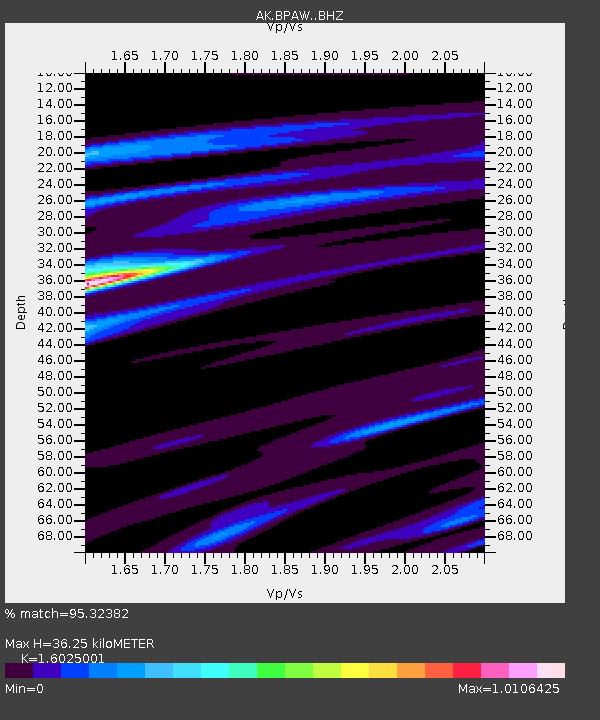
| Estimated Moho Depth: |
36.25 km |
| Estimated Crust Vp/Vs: |
1.60 |
| Assumed Crust Vp: |
6.566 km/s |
| Estimated Crust Vs: |
4.097 km/s |
| Estimated Crust Poisson's Ratio: |
0.18 |
|
| Radial Match: |
95.32382 % |
| Radial Bump: |
351 |
| Transverse Match: |
84.62225 % |
| Transverse Bump: |
400 |
| SOD ConfigId: |
30536071 |
| Insert Time: |
2023-06-03 01:52:44.768 +0000 |
| GWidth: |
2.5 |
| Max Bumps: |
400 |
| Tol: |
0.001 |
|

Signal To Noise
| Channel | StoN | STA | LTA |
| AK:BPAW: :BHZ:20230520T02:03:33.607971Z | 26.690596 | 2.4478134E-6 | 9.17107E-8 |
| AK:BPAW: :BHN:20230520T02:03:33.607971Z | 9.834528 | 6.662117E-7 | 6.7742114E-8 |
| AK:BPAW: :BHE:20230520T02:03:33.607971Z | 3.554229 | 3.122689E-7 | 8.78584E-8 |
| Arrivals |
| Ps | 3.4 SECOND |
| PpPs | 14 SECOND |
| PsPs/PpSs | 17 SECOND |


