You are here: Home > Network List > AK - Alaska Regional Network Stations List
> Station E21K Killik River, AK, USA > Earthquake Result Viewer
E21K Killik River, AK, USA - Earthquake Result Viewer
| Earthquake location: |
Southeast Of Loyalty Islands |
| Earthquake latitude/longitude: |
-23.1/170.4 |
| Earthquake time(UTC): |
2023/05/20 (140) 01:51:01 GMT |
| Earthquake Depth: |
45 km |
| Earthquake Magnitude: |
7.4 Mi |
| Earthquake Catalog/Contributor: |
NEIC PDE/at |
|
| Network: |
AK Alaska Regional Network |
| Station: |
E21K Killik River, AK, USA |
| Lat/Lon: |
68.44 N/153.97 W |
| Elevation: |
653 m |
|
| Distance: |
94.9 deg |
| Az: |
12.48 deg |
| Baz: |
212.572 deg |
| Ray Param: |
0.040902093 |
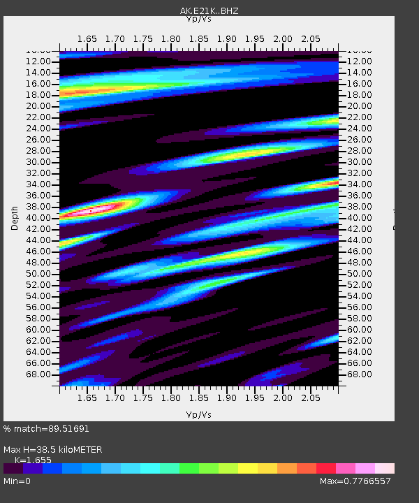
| Estimated Moho Depth: |
38.5 km |
| Estimated Crust Vp/Vs: |
1.65 |
| Assumed Crust Vp: |
6.221 km/s |
| Estimated Crust Vs: |
3.759 km/s |
| Estimated Crust Poisson's Ratio: |
0.21 |
|
| Radial Match: |
89.51691 % |
| Radial Bump: |
400 |
| Transverse Match: |
84.613625 % |
| Transverse Bump: |
400 |
| SOD ConfigId: |
30536071 |
| Insert Time: |
2023-06-03 01:53:20.837 +0000 |
| GWidth: |
2.5 |
| Max Bumps: |
400 |
| Tol: |
0.001 |
|

Signal To Noise
| Channel | StoN | STA | LTA |
| AK:E21K: :BHZ:20230520T02:03:47.099976Z | 26.116222 | 2.0420205E-6 | 7.8189736E-8 |
| AK:E21K: :BHN:20230520T02:03:47.099976Z | 10.291879 | 4.254278E-7 | 4.1336264E-8 |
| AK:E21K: :BHE:20230520T02:03:47.099976Z | 4.987822 | 3.0203256E-7 | 6.0554E-8 |
| Arrivals |
| Ps | 4.1 SECOND |
| PpPs | 16 SECOND |
| PsPs/PpSs | 20 SECOND |


