You are here: Home > Network List > AK - Alaska Regional Network Stations List
> Station L22K Petersville, AK, USA > Earthquake Result Viewer
L22K Petersville, AK, USA - Earthquake Result Viewer
| Earthquake location: |
Southeast Of Loyalty Islands |
| Earthquake latitude/longitude: |
-23.1/170.4 |
| Earthquake time(UTC): |
2023/05/20 (140) 01:51:01 GMT |
| Earthquake Depth: |
45 km |
| Earthquake Magnitude: |
7.4 Mi |
| Earthquake Catalog/Contributor: |
NEIC PDE/at |
|
| Network: |
AK Alaska Regional Network |
| Station: |
L22K Petersville, AK, USA |
| Lat/Lon: |
62.53 N/150.77 W |
| Elevation: |
817 m |
|
| Distance: |
90.7 deg |
| Az: |
16.907 deg |
| Baz: |
215.266 deg |
| Ray Param: |
0.041672587 |
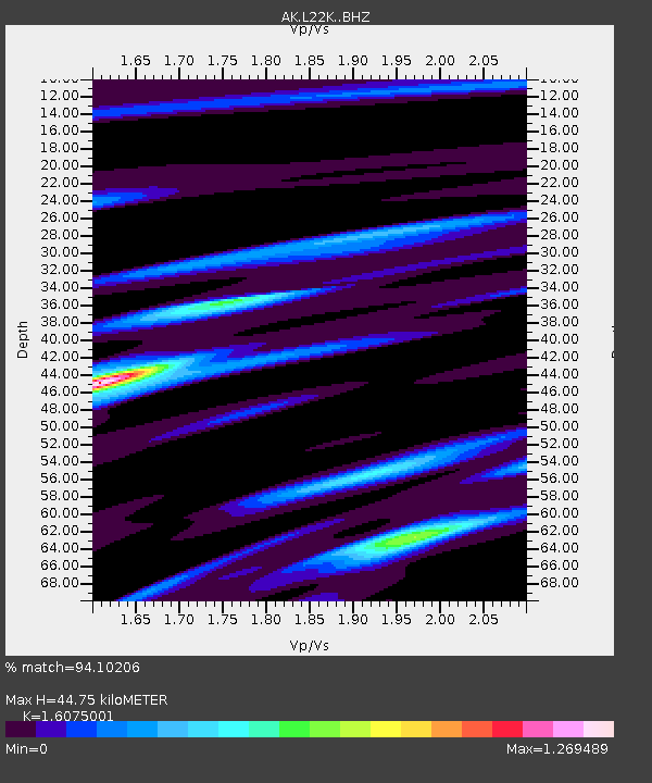
| Estimated Moho Depth: |
44.75 km |
| Estimated Crust Vp/Vs: |
1.61 |
| Assumed Crust Vp: |
6.438 km/s |
| Estimated Crust Vs: |
4.005 km/s |
| Estimated Crust Poisson's Ratio: |
0.18 |
|
| Radial Match: |
94.10206 % |
| Radial Bump: |
400 |
| Transverse Match: |
85.84854 % |
| Transverse Bump: |
400 |
| SOD ConfigId: |
30536071 |
| Insert Time: |
2023-06-03 01:54:42.150 +0000 |
| GWidth: |
2.5 |
| Max Bumps: |
400 |
| Tol: |
0.001 |
|

Signal To Noise
| Channel | StoN | STA | LTA |
| AK:L22K: :BHZ:20230520T02:03:27.900024Z | 34.21845 | 3.0387707E-6 | 8.8805045E-8 |
| AK:L22K: :BHN:20230520T02:03:27.900024Z | 8.374346 | 7.5869343E-7 | 9.059734E-8 |
| AK:L22K: :BHE:20230520T02:03:27.900024Z | 11.442739 | 8.5398557E-7 | 7.4631224E-8 |
| Arrivals |
| Ps | 4.3 SECOND |
| PpPs | 18 SECOND |
| PsPs/PpSs | 22 SECOND |


