You are here: Home > Network List > AV - Alaska Volcano Observatory Stations List
> Station CAHL Cahill, Katmai, Alaska > Earthquake Result Viewer
CAHL Cahill, Katmai, Alaska - Earthquake Result Viewer
| Earthquake location: |
Southeast Of Loyalty Islands |
| Earthquake latitude/longitude: |
-23.1/170.4 |
| Earthquake time(UTC): |
2023/05/20 (140) 01:51:01 GMT |
| Earthquake Depth: |
45 km |
| Earthquake Magnitude: |
7.4 Mi |
| Earthquake Catalog/Contributor: |
NEIC PDE/at |
|
| Network: |
AV Alaska Volcano Observatory |
| Station: |
CAHL Cahill, Katmai, Alaska |
| Lat/Lon: |
58.05 N/155.30 W |
| Elevation: |
807 m |
|
| Distance: |
85.8 deg |
| Az: |
17.484 deg |
| Baz: |
211.35 deg |
| Ray Param: |
0.04447106 |
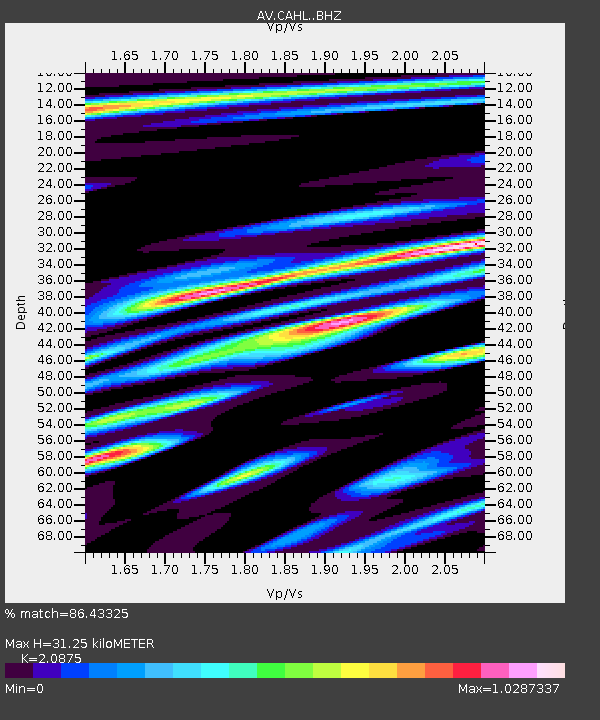
| Estimated Moho Depth: |
31.25 km |
| Estimated Crust Vp/Vs: |
2.09 |
| Assumed Crust Vp: |
6.438 km/s |
| Estimated Crust Vs: |
3.084 km/s |
| Estimated Crust Poisson's Ratio: |
0.35 |
|
| Radial Match: |
86.43325 % |
| Radial Bump: |
400 |
| Transverse Match: |
84.92483 % |
| Transverse Bump: |
400 |
| SOD ConfigId: |
30536071 |
| Insert Time: |
2023-06-03 01:58:10.785 +0000 |
| GWidth: |
2.5 |
| Max Bumps: |
400 |
| Tol: |
0.001 |
|

Signal To Noise
| Channel | StoN | STA | LTA |
| AV:CAHL: :BHZ:20230520T02:03:04.219971Z | 17.577934 | 8.644507E-6 | 4.9178175E-7 |
| AV:CAHL: :BHN:20230520T02:03:04.219971Z | 3.8227017 | 2.5460054E-6 | 6.6602246E-7 |
| AV:CAHL: :BHE:20230520T02:03:04.219971Z | 2.8453627 | 1.2063111E-6 | 4.239569E-7 |
| Arrivals |
| Ps | 5.4 SECOND |
| PpPs | 15 SECOND |
| PsPs/PpSs | 20 SECOND |


