You are here: Home > Network List > AV - Alaska Volcano Observatory Stations List
> Station CEAP Anvil Peak, Cerberus Volcano, Alaska > Earthquake Result Viewer
CEAP Anvil Peak, Cerberus Volcano, Alaska - Earthquake Result Viewer
| Earthquake location: |
Southeast Of Loyalty Islands |
| Earthquake latitude/longitude: |
-23.1/170.4 |
| Earthquake time(UTC): |
2023/05/20 (140) 01:51:01 GMT |
| Earthquake Depth: |
45 km |
| Earthquake Magnitude: |
7.4 Mi |
| Earthquake Catalog/Contributor: |
NEIC PDE/at |
|
| Network: |
AV Alaska Volcano Observatory |
| Station: |
CEAP Anvil Peak, Cerberus Volcano, Alaska |
| Lat/Lon: |
52.00 N/179.58 E |
| Elevation: |
244 m |
|
| Distance: |
75.2 deg |
| Az: |
5.852 deg |
| Baz: |
188.735 deg |
| Ray Param: |
0.051748235 |
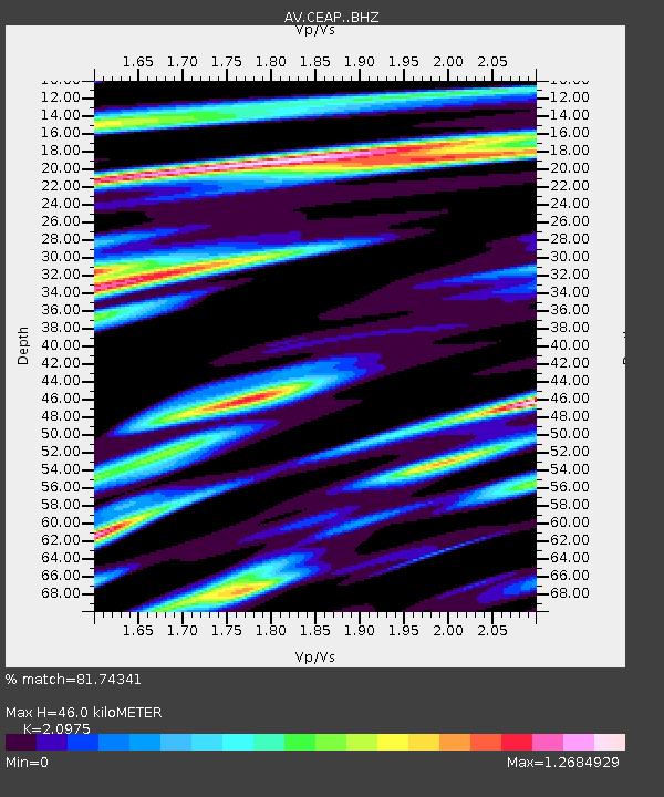
| Estimated Moho Depth: |
46.0 km |
| Estimated Crust Vp/Vs: |
2.10 |
| Assumed Crust Vp: |
6.183 km/s |
| Estimated Crust Vs: |
2.948 km/s |
| Estimated Crust Poisson's Ratio: |
0.35 |
|
| Radial Match: |
81.74341 % |
| Radial Bump: |
400 |
| Transverse Match: |
74.183586 % |
| Transverse Bump: |
400 |
| SOD ConfigId: |
30536071 |
| Insert Time: |
2023-06-03 01:58:11.059 +0000 |
| GWidth: |
2.5 |
| Max Bumps: |
400 |
| Tol: |
0.001 |
|

Signal To Noise
| Channel | StoN | STA | LTA |
| AV:CEAP: :BHZ:20230520T02:02:07.919983Z | 11.341341 | 8.307429E-6 | 7.3249095E-7 |
| AV:CEAP: :BHN:20230520T02:02:07.919983Z | 3.2214653 | 3.57724E-6 | 1.1104387E-6 |
| AV:CEAP: :BHE:20230520T02:02:07.919983Z | 1.131327 | 1.2505384E-6 | 1.105373E-6 |
| Arrivals |
| Ps | 8.4 SECOND |
| PpPs | 22 SECOND |
| PsPs/PpSs | 31 SECOND |


