You are here: Home > Network List > AV - Alaska Volcano Observatory Stations List
> Station CERA Ragged Top, Cerberus Volcano, Alaska > Earthquake Result Viewer
CERA Ragged Top, Cerberus Volcano, Alaska - Earthquake Result Viewer
| Earthquake location: |
Southeast Of Loyalty Islands |
| Earthquake latitude/longitude: |
-23.1/170.4 |
| Earthquake time(UTC): |
2023/05/20 (140) 01:51:01 GMT |
| Earthquake Depth: |
45 km |
| Earthquake Magnitude: |
7.4 Mi |
| Earthquake Catalog/Contributor: |
NEIC PDE/at |
|
| Network: |
AV Alaska Volcano Observatory |
| Station: |
CERA Ragged Top, Cerberus Volcano, Alaska |
| Lat/Lon: |
51.91 N/179.68 E |
| Elevation: |
305 m |
|
| Distance: |
75.1 deg |
| Az: |
5.935 deg |
| Baz: |
188.84 deg |
| Ray Param: |
0.05180132 |
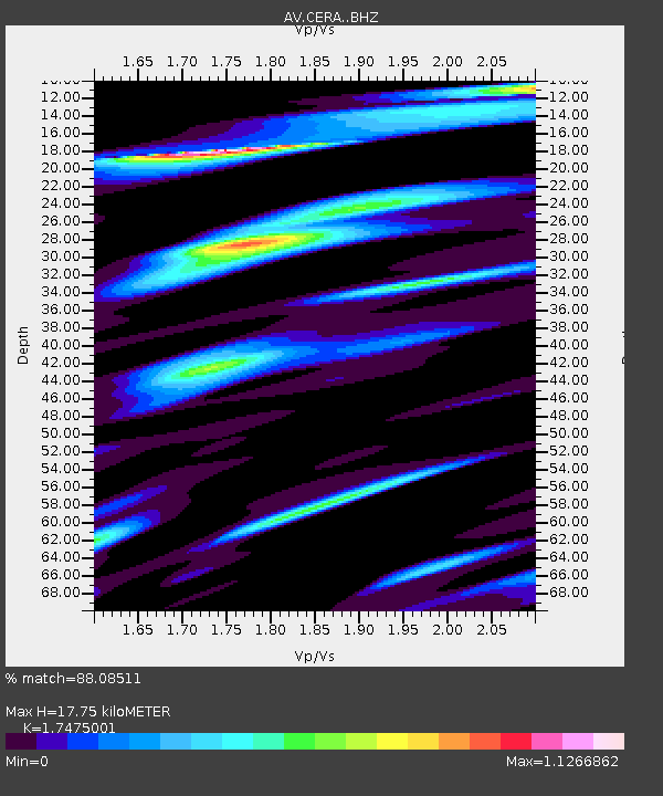
| Estimated Moho Depth: |
17.75 km |
| Estimated Crust Vp/Vs: |
1.75 |
| Assumed Crust Vp: |
6.183 km/s |
| Estimated Crust Vs: |
3.538 km/s |
| Estimated Crust Poisson's Ratio: |
0.26 |
|
| Radial Match: |
88.08511 % |
| Radial Bump: |
400 |
| Transverse Match: |
76.560715 % |
| Transverse Bump: |
400 |
| SOD ConfigId: |
30536071 |
| Insert Time: |
2023-06-03 01:58:14.402 +0000 |
| GWidth: |
2.5 |
| Max Bumps: |
400 |
| Tol: |
0.001 |
|

Signal To Noise
| Channel | StoN | STA | LTA |
| AV:CERA: :BHZ:20230520T02:02:07.439026Z | 22.120035 | 9.550245E-6 | 4.3174637E-7 |
| AV:CERA: :BHN:20230520T02:02:07.439026Z | 3.9954216 | 4.1382036E-6 | 1.0357364E-6 |
| AV:CERA: :BHE:20230520T02:02:07.439026Z | 1.752901 | 1.9936163E-6 | 1.137324E-6 |
| Arrivals |
| Ps | 2.2 SECOND |
| PpPs | 7.7 SECOND |
| PsPs/PpSs | 9.9 SECOND |


