You are here: Home > Network List > AV - Alaska Volcano Observatory Stations List
> Station KEL Katmai Kelez, Alaska > Earthquake Result Viewer
KEL Katmai Kelez, Alaska - Earthquake Result Viewer
| Earthquake location: |
Southeast Of Loyalty Islands |
| Earthquake latitude/longitude: |
-23.1/170.4 |
| Earthquake time(UTC): |
2023/05/20 (140) 01:51:01 GMT |
| Earthquake Depth: |
45 km |
| Earthquake Magnitude: |
7.4 Mi |
| Earthquake Catalog/Contributor: |
NEIC PDE/at |
|
| Network: |
AV Alaska Volcano Observatory |
| Station: |
KEL Katmai Kelez, Alaska |
| Lat/Lon: |
58.44 N/155.74 W |
| Elevation: |
975 m |
|
| Distance: |
86.0 deg |
| Az: |
17.083 deg |
| Baz: |
210.948 deg |
| Ray Param: |
0.04432261 |
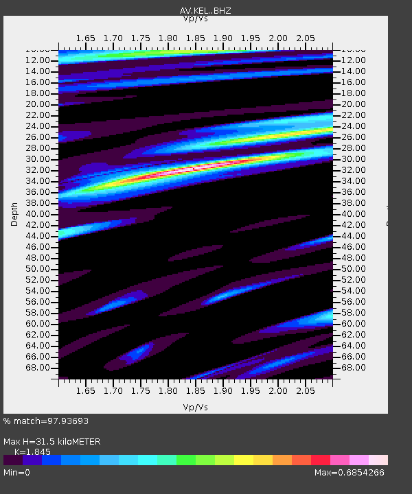
| Estimated Moho Depth: |
31.5 km |
| Estimated Crust Vp/Vs: |
1.85 |
| Assumed Crust Vp: |
6.438 km/s |
| Estimated Crust Vs: |
3.49 km/s |
| Estimated Crust Poisson's Ratio: |
0.29 |
|
| Radial Match: |
97.93693 % |
| Radial Bump: |
392 |
| Transverse Match: |
92.24612 % |
| Transverse Bump: |
400 |
| SOD ConfigId: |
30536071 |
| Insert Time: |
2023-06-03 01:59:13.962 +0000 |
| GWidth: |
2.5 |
| Max Bumps: |
400 |
| Tol: |
0.001 |
|

Signal To Noise
| Channel | StoN | STA | LTA |
| AV:KEL: :BHZ:20230520T02:03:05.278992Z | 34.304012 | 8.513332E-6 | 2.481731E-7 |
| AV:KEL: :BHN:20230520T02:03:05.278992Z | 9.879718 | 2.2788704E-6 | 2.306615E-7 |
| AV:KEL: :BHE:20230520T02:03:05.278992Z | 6.1124454 | 1.540833E-6 | 2.5208126E-7 |
| Arrivals |
| Ps | 4.2 SECOND |
| PpPs | 14 SECOND |
| PsPs/PpSs | 18 SECOND |


