You are here: Home > Network List > AV - Alaska Volcano Observatory Stations List
> Station KJL Kejulik, Katmai, Alaska > Earthquake Result Viewer
KJL Kejulik, Katmai, Alaska - Earthquake Result Viewer
| Earthquake location: |
Southeast Of Loyalty Islands |
| Earthquake latitude/longitude: |
-23.1/170.4 |
| Earthquake time(UTC): |
2023/05/20 (140) 01:51:01 GMT |
| Earthquake Depth: |
45 km |
| Earthquake Magnitude: |
7.4 Mi |
| Earthquake Catalog/Contributor: |
NEIC PDE/at |
|
| Network: |
AV Alaska Volcano Observatory |
| Station: |
KJL Kejulik, Katmai, Alaska |
| Lat/Lon: |
58.05 N/155.58 W |
| Elevation: |
792 m |
|
| Distance: |
85.7 deg |
| Az: |
17.359 deg |
| Baz: |
211.11 deg |
| Ray Param: |
0.04452021 |
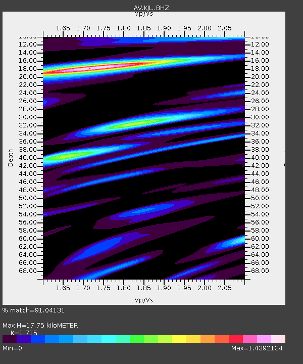
| Estimated Moho Depth: |
17.75 km |
| Estimated Crust Vp/Vs: |
1.72 |
| Assumed Crust Vp: |
6.438 km/s |
| Estimated Crust Vs: |
3.754 km/s |
| Estimated Crust Poisson's Ratio: |
0.24 |
|
| Radial Match: |
91.04131 % |
| Radial Bump: |
400 |
| Transverse Match: |
80.26688 % |
| Transverse Bump: |
400 |
| SOD ConfigId: |
30536071 |
| Insert Time: |
2023-06-03 01:59:23.571 +0000 |
| GWidth: |
2.5 |
| Max Bumps: |
400 |
| Tol: |
0.001 |
|
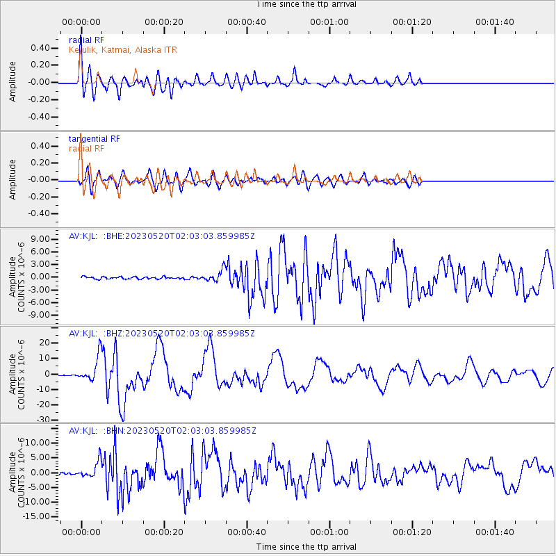
Signal To Noise
| Channel | StoN | STA | LTA |
| AV:KJL: :BHZ:20230520T02:03:03.859985Z | 26.64558 | 8.687283E-6 | 3.2603094E-7 |
| AV:KJL: :BHN:20230520T02:03:03.859985Z | 6.476727 | 2.9333314E-6 | 4.5290338E-7 |
| AV:KJL: :BHE:20230520T02:03:03.859985Z | 5.60517 | 1.3979861E-6 | 2.4941014E-7 |
| Arrivals |
| Ps | 2.0 SECOND |
| PpPs | 7.3 SECOND |
| PsPs/PpSs | 9.3 SECOND |


