You are here: Home > Network List > AV - Alaska Volcano Observatory Stations List
> Station KOSE Southeast, Korovin Volcano, Alaska > Earthquake Result Viewer
KOSE Southeast, Korovin Volcano, Alaska - Earthquake Result Viewer
| Earthquake location: |
Southeast Of Loyalty Islands |
| Earthquake latitude/longitude: |
-23.1/170.4 |
| Earthquake time(UTC): |
2023/05/20 (140) 01:51:01 GMT |
| Earthquake Depth: |
45 km |
| Earthquake Magnitude: |
7.4 Mi |
| Earthquake Catalog/Contributor: |
NEIC PDE/at |
|
| Network: |
AV Alaska Volcano Observatory |
| Station: |
KOSE Southeast, Korovin Volcano, Alaska |
| Lat/Lon: |
52.34 N/174.05 W |
| Elevation: |
625 m |
|
| Distance: |
76.3 deg |
| Az: |
9.744 deg |
| Baz: |
194.715 deg |
| Ray Param: |
0.05098859 |
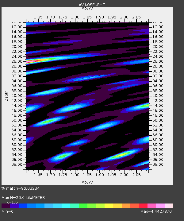
| Estimated Moho Depth: |
26.0 km |
| Estimated Crust Vp/Vs: |
1.60 |
| Assumed Crust Vp: |
5.88 km/s |
| Estimated Crust Vs: |
3.675 km/s |
| Estimated Crust Poisson's Ratio: |
0.18 |
|
| Radial Match: |
90.63234 % |
| Radial Bump: |
400 |
| Transverse Match: |
88.636894 % |
| Transverse Bump: |
400 |
| SOD ConfigId: |
30536071 |
| Insert Time: |
2023-06-03 01:59:33.555 +0000 |
| GWidth: |
2.5 |
| Max Bumps: |
400 |
| Tol: |
0.001 |
|

Signal To Noise
| Channel | StoN | STA | LTA |
| AV:KOSE: :BHZ:20230520T02:02:14.379028Z | 22.781084 | 1.2800259E-5 | 5.6188105E-7 |
| AV:KOSE: :BHN:20230520T02:02:14.379028Z | 3.2896454 | 5.966564E-6 | 1.8137408E-6 |
| AV:KOSE: :BHE:20230520T02:02:14.379028Z | 1.3121822 | 3.0404121E-6 | 2.3170658E-6 |
| Arrivals |
| Ps | 2.7 SECOND |
| PpPs | 11 SECOND |
| PsPs/PpSs | 14 SECOND |


