You are here: Home > Network List > AV - Alaska Volcano Observatory Stations List
> Station MAPS Pakushin Southeast, Makushin Volcano, Alaska > Earthquake Result Viewer
MAPS Pakushin Southeast, Makushin Volcano, Alaska - Earthquake Result Viewer
| Earthquake location: |
Southeast Of Loyalty Islands |
| Earthquake latitude/longitude: |
-23.1/170.4 |
| Earthquake time(UTC): |
2023/05/20 (140) 01:51:01 GMT |
| Earthquake Depth: |
45 km |
| Earthquake Magnitude: |
7.4 Mi |
| Earthquake Catalog/Contributor: |
NEIC PDE/at |
|
| Network: |
AV Alaska Volcano Observatory |
| Station: |
MAPS Pakushin Southeast, Makushin Volcano, Alaska |
| Lat/Lon: |
53.81 N/166.94 W |
| Elevation: |
333 m |
|
| Distance: |
79.1 deg |
| Az: |
13.457 deg |
| Baz: |
201.18 deg |
| Ray Param: |
0.049150847 |
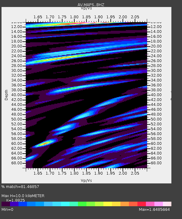
| Estimated Moho Depth: |
10.0 km |
| Estimated Crust Vp/Vs: |
1.88 |
| Assumed Crust Vp: |
3.943 km/s |
| Estimated Crust Vs: |
2.095 km/s |
| Estimated Crust Poisson's Ratio: |
0.30 |
|
| Radial Match: |
81.46857 % |
| Radial Bump: |
400 |
| Transverse Match: |
82.899445 % |
| Transverse Bump: |
400 |
| SOD ConfigId: |
30536071 |
| Insert Time: |
2023-06-03 01:59:42.996 +0000 |
| GWidth: |
2.5 |
| Max Bumps: |
400 |
| Tol: |
0.001 |
|
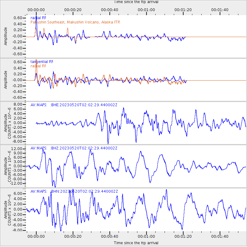
Signal To Noise
| Channel | StoN | STA | LTA |
| AV:MAPS: :BHZ:20230520T02:02:29.440002Z | 13.011199 | 5.726144E-6 | 4.4009352E-7 |
| AV:MAPS: :BHN:20230520T02:02:29.440002Z | 2.8207676 | 2.2999045E-6 | 8.1534705E-7 |
| AV:MAPS: :BHE:20230520T02:02:29.440002Z | 4.181602 | 1.9985598E-6 | 4.7794117E-7 |
| Arrivals |
| Ps | 2.3 SECOND |
| PpPs | 7.2 SECOND |
| PsPs/PpSs | 9.5 SECOND |


