You are here: Home > Network List > AV - Alaska Volcano Observatory Stations List
> Station SPCR Ckakachatna River, Mount Spurr, Alaska > Earthquake Result Viewer
SPCR Ckakachatna River, Mount Spurr, Alaska - Earthquake Result Viewer
| Earthquake location: |
Southeast Of Loyalty Islands |
| Earthquake latitude/longitude: |
-23.1/170.4 |
| Earthquake time(UTC): |
2023/05/20 (140) 01:51:01 GMT |
| Earthquake Depth: |
45 km |
| Earthquake Magnitude: |
7.4 Mi |
| Earthquake Catalog/Contributor: |
NEIC PDE/at |
|
| Network: |
AV Alaska Volcano Observatory |
| Station: |
SPCR Ckakachatna River, Mount Spurr, Alaska |
| Lat/Lon: |
61.20 N/152.21 W |
| Elevation: |
984 m |
|
| Distance: |
89.3 deg |
| Az: |
17.102 deg |
| Baz: |
213.999 deg |
| Ray Param: |
0.041916132 |
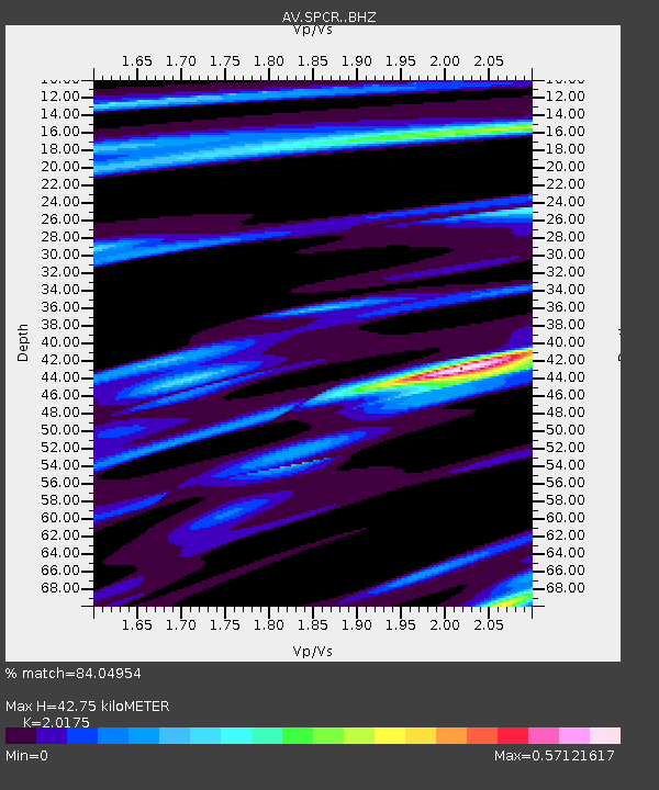
| Estimated Moho Depth: |
42.75 km |
| Estimated Crust Vp/Vs: |
2.02 |
| Assumed Crust Vp: |
6.566 km/s |
| Estimated Crust Vs: |
3.255 km/s |
| Estimated Crust Poisson's Ratio: |
0.34 |
|
| Radial Match: |
84.04954 % |
| Radial Bump: |
400 |
| Transverse Match: |
82.962425 % |
| Transverse Bump: |
400 |
| SOD ConfigId: |
30536071 |
| Insert Time: |
2023-06-03 02:00:39.244 +0000 |
| GWidth: |
2.5 |
| Max Bumps: |
400 |
| Tol: |
0.001 |
|

Signal To Noise
| Channel | StoN | STA | LTA |
| AV:SPCR: :BHZ:20230520T02:03:21.039978Z | 38.116074 | 3.6170823E-6 | 9.489651E-8 |
| AV:SPCR: :BHN:20230520T02:03:21.039978Z | 10.269803 | 1.1053652E-6 | 1.0763255E-7 |
| AV:SPCR: :BHE:20230520T02:03:21.039978Z | 5.706682 | 4.0883563E-7 | 7.164156E-8 |
| Arrivals |
| Ps | 6.8 SECOND |
| PpPs | 19 SECOND |
| PsPs/PpSs | 26 SECOND |


