You are here: Home > Network List > XA97 - Anatomy of an Archean Craton, South Africa Stations List
> Station SA32 XA.SA32 > Earthquake Result Viewer
SA32 XA.SA32 - Earthquake Result Viewer
| Earthquake location: |
South Sandwich Islands Region |
| Earthquake latitude/longitude: |
-59.7/-29.2 |
| Earthquake time(UTC): |
1997/10/05 (278) 18:04:30 GMT |
| Earthquake Depth: |
274 km |
| Earthquake Magnitude: |
6.0 MB, 6.3 UNKNOWN, 6.3 MW |
| Earthquake Catalog/Contributor: |
WHDF/NEIC |
|
| Network: |
XA Anatomy of an Archean Craton, South Africa |
| Station: |
SA32 XA.SA32 |
| Lat/Lon: |
26.87 S/26.28 E |
| Elevation: |
1380 m |
|
| Distance: |
49.9 deg |
| Az: |
74.161 deg |
| Baz: |
213.055 deg |
| Ray Param: |
0.06735397 |
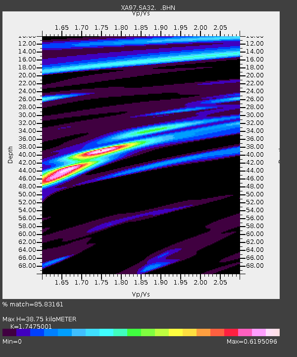
| Estimated Moho Depth: |
38.75 km |
| Estimated Crust Vp/Vs: |
1.75 |
| Assumed Crust Vp: |
6.459 km/s |
| Estimated Crust Vs: |
3.696 km/s |
| Estimated Crust Poisson's Ratio: |
0.26 |
|
| Radial Match: |
85.83161 % |
| Radial Bump: |
333 |
| Transverse Match: |
69.7665 % |
| Transverse Bump: |
400 |
| SOD ConfigId: |
6273 |
| Insert Time: |
2010-02-26 18:10:10.956 +0000 |
| GWidth: |
2.5 |
| Max Bumps: |
400 |
| Tol: |
0.001 |
|
Signal To Noise
| Channel | StoN | STA | LTA |
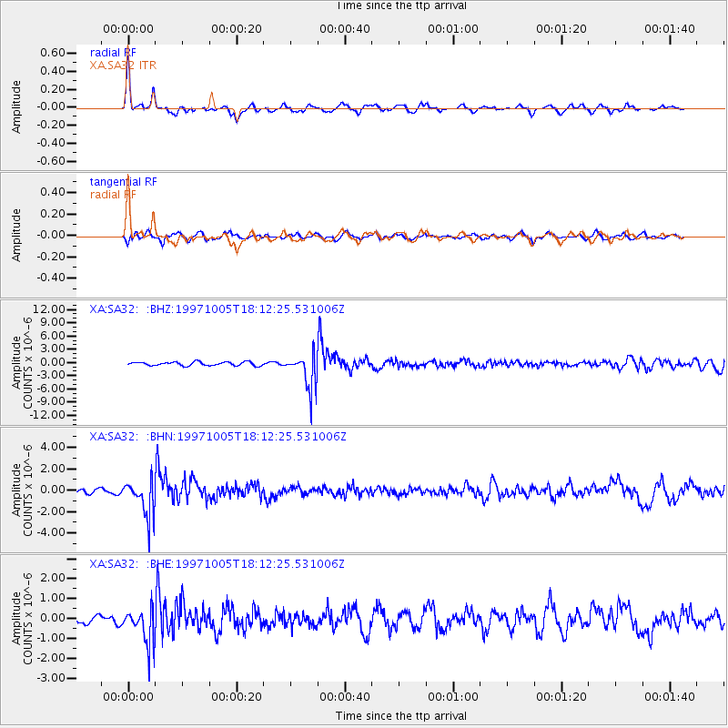
| XA:SA32: :BHN:19971005T18:12:25.531006Z | 6.9331355 | 1.6900663E-6 | 2.4376652E-7 |
| XA:SA32: :BHE:19971005T18:12:25.531006Z | 3.6096575 | 8.9920087E-7 | 2.4910975E-7 |
| XA:SA32: :BHZ:19971005T18:12:25.531006Z | 9.822579 | 3.996232E-6 | 4.068414E-7 |
| Arrivals |
| Ps | 4.8 SECOND |
| PpPs | 16 SECOND |
| PsPs/PpSs | 20 SECOND |


