You are here: Home > Network List > AV - Alaska Volcano Observatory Stations List
> Station TAFL Flats, Tanaga Volcano, Alaska > Earthquake Result Viewer
TAFL Flats, Tanaga Volcano, Alaska - Earthquake Result Viewer
| Earthquake location: |
Southeast Of Loyalty Islands |
| Earthquake latitude/longitude: |
-23.1/170.4 |
| Earthquake time(UTC): |
2023/05/20 (140) 01:51:01 GMT |
| Earthquake Depth: |
45 km |
| Earthquake Magnitude: |
7.4 Mi |
| Earthquake Catalog/Contributor: |
NEIC PDE/at |
|
| Network: |
AV Alaska Volcano Observatory |
| Station: |
TAFL Flats, Tanaga Volcano, Alaska |
| Lat/Lon: |
51.76 N/177.90 W |
| Elevation: |
186 m |
|
| Distance: |
75.2 deg |
| Az: |
7.49 deg |
| Baz: |
191.134 deg |
| Ray Param: |
0.051730596 |
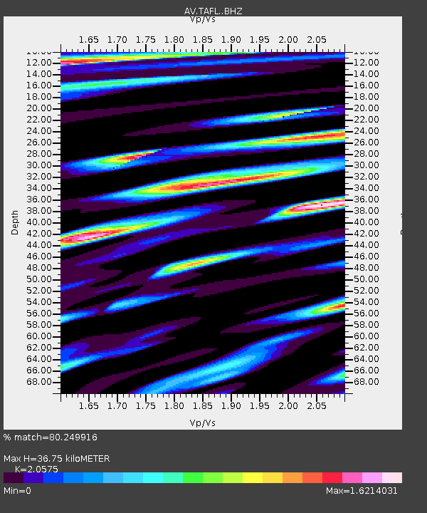
| Estimated Moho Depth: |
36.75 km |
| Estimated Crust Vp/Vs: |
2.06 |
| Assumed Crust Vp: |
5.88 km/s |
| Estimated Crust Vs: |
2.858 km/s |
| Estimated Crust Poisson's Ratio: |
0.35 |
|
| Radial Match: |
80.249916 % |
| Radial Bump: |
400 |
| Transverse Match: |
89.79455 % |
| Transverse Bump: |
400 |
| SOD ConfigId: |
30536071 |
| Insert Time: |
2023-06-03 02:00:50.683 +0000 |
| GWidth: |
2.5 |
| Max Bumps: |
400 |
| Tol: |
0.001 |
|

Signal To Noise
| Channel | StoN | STA | LTA |
| AV:TAFL: :BHZ:20230520T02:02:08.080017Z | 16.841444 | 1.0938865E-5 | 6.4952053E-7 |
| AV:TAFL: :BHN:20230520T02:02:08.080017Z | 2.717812 | 3.0882031E-6 | 1.1362828E-6 |
| AV:TAFL: :BHE:20230520T02:02:08.080017Z | 1.5608878 | 1.262271E-6 | 8.0868784E-7 |
| Arrivals |
| Ps | 6.8 SECOND |
| PpPs | 19 SECOND |
| PsPs/PpSs | 25 SECOND |


