You are here: Home > Network List > AV - Alaska Volcano Observatory Stations List
> Station VNKR Kametolook River, Mount Veniaminof, Alaska > Earthquake Result Viewer
VNKR Kametolook River, Mount Veniaminof, Alaska - Earthquake Result Viewer
| Earthquake location: |
Southeast Of Loyalty Islands |
| Earthquake latitude/longitude: |
-23.1/170.4 |
| Earthquake time(UTC): |
2023/05/20 (140) 01:51:01 GMT |
| Earthquake Depth: |
45 km |
| Earthquake Magnitude: |
7.4 Mi |
| Earthquake Catalog/Contributor: |
NEIC PDE/at |
|
| Network: |
AV Alaska Volcano Observatory |
| Station: |
VNKR Kametolook River, Mount Veniaminof, Alaska |
| Lat/Lon: |
56.03 N/159.37 W |
| Elevation: |
620 m |
|
| Distance: |
82.9 deg |
| Az: |
16.547 deg |
| Baz: |
207.851 deg |
| Ray Param: |
0.046501722 |
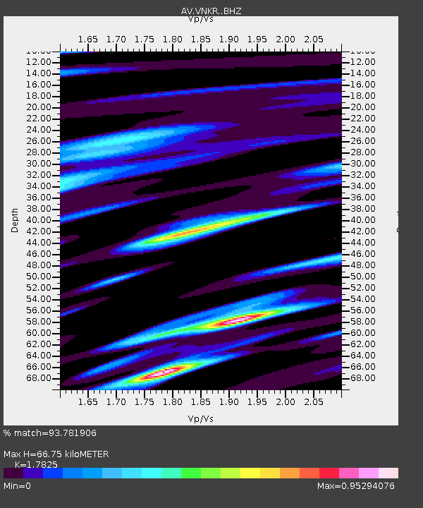
| Estimated Moho Depth: |
66.75 km |
| Estimated Crust Vp/Vs: |
1.78 |
| Assumed Crust Vp: |
6.134 km/s |
| Estimated Crust Vs: |
3.441 km/s |
| Estimated Crust Poisson's Ratio: |
0.27 |
|
| Radial Match: |
93.781906 % |
| Radial Bump: |
400 |
| Transverse Match: |
83.02764 % |
| Transverse Bump: |
400 |
| SOD ConfigId: |
30536071 |
| Insert Time: |
2023-06-03 02:01:00.579 +0000 |
| GWidth: |
2.5 |
| Max Bumps: |
400 |
| Tol: |
0.001 |
|

Signal To Noise
| Channel | StoN | STA | LTA |
| AV:VNKR: :BHZ:20230520T02:02:49.799011Z | 13.640124 | 8.617729E-6 | 6.3179255E-7 |
| AV:VNKR: :BHN:20230520T02:02:49.799011Z | 1.8549145 | 2.5362378E-6 | 1.3673072E-6 |
| AV:VNKR: :BHE:20230520T02:02:49.799011Z | 2.8566492 | 2.9144571E-6 | 1.0202363E-6 |
| Arrivals |
| Ps | 8.7 SECOND |
| PpPs | 30 SECOND |
| PsPs/PpSs | 38 SECOND |


