You are here: Home > Network List > AZ - ANZA Regional Network Stations List
> Station SMER AZ.SMER > Earthquake Result Viewer
SMER AZ.SMER - Earthquake Result Viewer
| Earthquake location: |
Southeast Of Loyalty Islands |
| Earthquake latitude/longitude: |
-23.1/170.4 |
| Earthquake time(UTC): |
2023/05/20 (140) 01:51:01 GMT |
| Earthquake Depth: |
45 km |
| Earthquake Magnitude: |
7.4 Mi |
| Earthquake Catalog/Contributor: |
NEIC PDE/at |
|
| Network: |
AZ ANZA Regional Network |
| Station: |
SMER AZ.SMER |
| Lat/Lon: |
33.46 N/117.17 W |
| Elevation: |
355 m |
|
| Distance: |
89.0 deg |
| Az: |
52.856 deg |
| Baz: |
241.397 deg |
| Ray Param: |
0.042142432 |
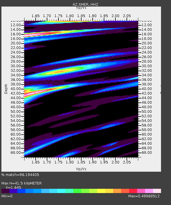
| Estimated Moho Depth: |
41.5 km |
| Estimated Crust Vp/Vs: |
1.64 |
| Assumed Crust Vp: |
6.264 km/s |
| Estimated Crust Vs: |
3.808 km/s |
| Estimated Crust Poisson's Ratio: |
0.21 |
|
| Radial Match: |
96.194405 % |
| Radial Bump: |
367 |
| Transverse Match: |
88.521355 % |
| Transverse Bump: |
349 |
| SOD ConfigId: |
30536071 |
| Insert Time: |
2023-06-03 02:01:32.988 +0000 |
| GWidth: |
2.5 |
| Max Bumps: |
400 |
| Tol: |
0.001 |
|
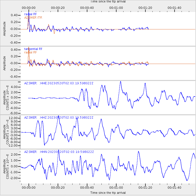
Signal To Noise
| Channel | StoN | STA | LTA |
| AZ:SMER: :HHZ:20230520T02:03:19.598022Z | 11.200911 | 1.3781781E-6 | 1.2304162E-7 |
| AZ:SMER: :HHN:20230520T02:03:19.598022Z | 1.0573505 | 2.5502212E-7 | 2.4118975E-7 |
| AZ:SMER: :HHE:20230520T02:03:19.598022Z | 4.8645763 | 4.802095E-7 | 9.871558E-8 |
| Arrivals |
| Ps | 4.4 SECOND |
| PpPs | 17 SECOND |
| PsPs/PpSs | 22 SECOND |


