You are here: Home > Network List > TA - USArray Transportable Network (new EarthScope stations) Stations List
> Station G21A Lodge Grass, MT, USA > Earthquake Result Viewer
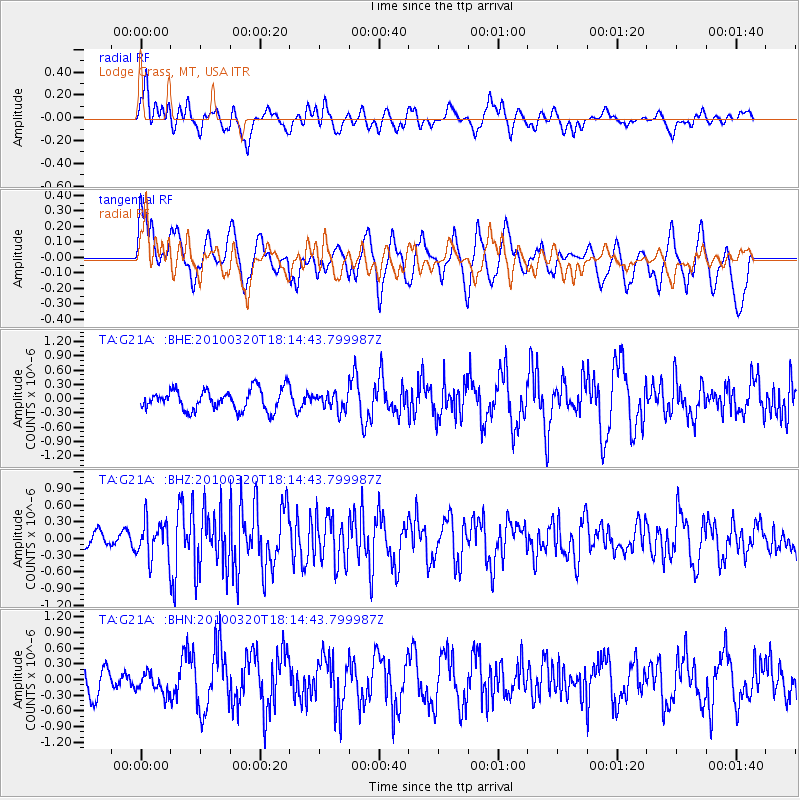
G21A Lodge Grass, MT, USA - Earthquake Result Viewer
*The percent match for this event was below the threshold and hence no stack was calculated.
| Earthquake location: |
Cuba Region |
| Earthquake latitude/longitude: |
19.7/-75.3 |
| Earthquake time(UTC): |
2010/03/20 (079) 18:08:08 GMT |
| Earthquake Depth: |
15 km |
| Earthquake Magnitude: |
5.5 MB, 5.4 MS, 5.6 MW, 5.6 MW |
| Earthquake Catalog/Contributor: |
WHDF/NEIC |
|
| Network: |
TA USArray Transportable Network (new EarthScope stations) |
| Station: |
G21A Lodge Grass, MT, USA |
| Lat/Lon: |
45.22 N/107.21 W |
| Elevation: |
1227 m |
|
| Distance: |
36.6 deg |
| Az: |
321.302 deg |
| Baz: |
123.522 deg |
| Ray Param: |
$rayparam |
*The percent match for this event was below the threshold and hence was not used in the summary stack. |
|
| Radial Match: |
55.13842 % |
| Radial Bump: |
400 |
| Transverse Match: |
60.43845 % |
| Transverse Bump: |
400 |
| SOD ConfigId: |
308276 |
| Insert Time: |
2010-06-22 21:58:58.456 +0000 |
| GWidth: |
2.5 |
| Max Bumps: |
400 |
| Tol: |
0.001 |
|
Signal To Noise
| Channel | StoN | STA | LTA |
| TA:G21A: :BHZ:20100320T18:14:43.799987Z | 1.7092385 | 3.3379106E-7 | 1.9528642E-7 |
| TA:G21A: :BHN:20100320T18:14:43.799987Z | 0.7537068 | 2.0527484E-7 | 2.723537E-7 |
| TA:G21A: :BHE:20100320T18:14:43.799987Z | 0.7861742 | 1.7312654E-7 | 2.2021398E-7 |
| Arrivals |
| Ps | |
| PpPs | |
| PsPs/PpSs | |


