You are here: Home > Network List > TA - USArray Transportable Network (new EarthScope stations) Stations List
> Station I20A Worland, WY, USA > Earthquake Result Viewer
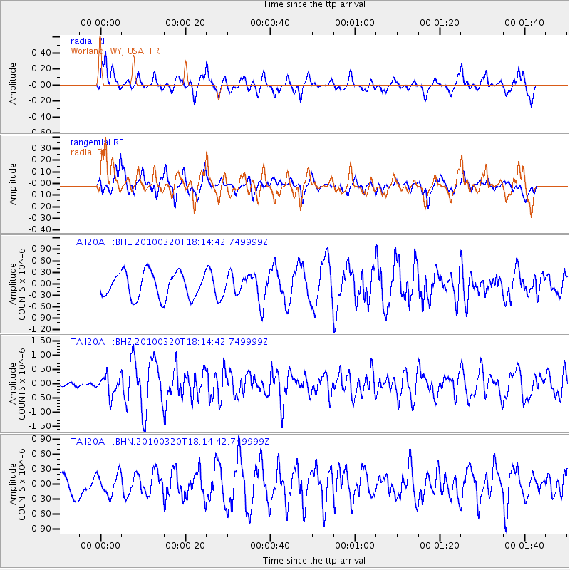
I20A Worland, WY, USA - Earthquake Result Viewer
*The percent match for this event was below the threshold and hence no stack was calculated.
| Earthquake location: |
Cuba Region |
| Earthquake latitude/longitude: |
19.7/-75.3 |
| Earthquake time(UTC): |
2010/03/20 (079) 18:08:08 GMT |
| Earthquake Depth: |
15 km |
| Earthquake Magnitude: |
5.5 MB, 5.4 MS, 5.6 MW, 5.6 MW |
| Earthquake Catalog/Contributor: |
WHDF/NEIC |
|
| Network: |
TA USArray Transportable Network (new EarthScope stations) |
| Station: |
I20A Worland, WY, USA |
| Lat/Lon: |
43.95 N/108.13 W |
| Elevation: |
1342 m |
|
| Distance: |
36.5 deg |
| Az: |
318.904 deg |
| Baz: |
120.952 deg |
| Ray Param: |
$rayparam |
*The percent match for this event was below the threshold and hence was not used in the summary stack. |
|
| Radial Match: |
69.373505 % |
| Radial Bump: |
400 |
| Transverse Match: |
69.652275 % |
| Transverse Bump: |
400 |
| SOD ConfigId: |
308276 |
| Insert Time: |
2010-06-22 21:59:06.446 +0000 |
| GWidth: |
2.5 |
| Max Bumps: |
400 |
| Tol: |
0.001 |
|
Signal To Noise
| Channel | StoN | STA | LTA |
| TA:I20A: :BHZ:20100320T18:14:42.749999Z | 2.2498763 | 3.4032243E-7 | 1.5126273E-7 |
| TA:I20A: :BHN:20100320T18:14:42.749999Z | 0.712195 | 2.0986461E-7 | 2.94673E-7 |
| TA:I20A: :BHE:20100320T18:14:42.749999Z | 0.7251678 | 2.3676172E-7 | 3.264923E-7 |
| Arrivals |
| Ps | |
| PpPs | |
| PsPs/PpSs | |


