You are here: Home > Network List > C8 - Canadian Seismic Research Network () Stations List
> Station GRIB Gribbell Island, BC, CA > Earthquake Result Viewer
GRIB Gribbell Island, BC, CA - Earthquake Result Viewer
| Earthquake location: |
Southeast Of Loyalty Islands |
| Earthquake latitude/longitude: |
-23.1/170.4 |
| Earthquake time(UTC): |
2023/05/20 (140) 01:51:01 GMT |
| Earthquake Depth: |
45 km |
| Earthquake Magnitude: |
7.4 Mi |
| Earthquake Catalog/Contributor: |
NEIC PDE/at |
|
| Network: |
C8 Canadian Seismic Research Network () |
| Station: |
GRIB Gribbell Island, BC, CA |
| Lat/Lon: |
53.34 N/129.14 W |
| Elevation: |
418 m |
|
| Distance: |
92.3 deg |
| Az: |
31.476 deg |
| Baz: |
233.296 deg |
| Ray Param: |
0.041467562 |
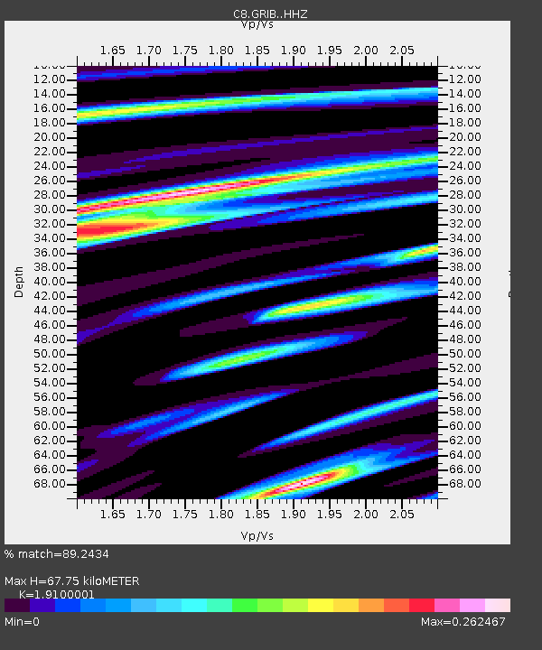
| Estimated Moho Depth: |
67.75 km |
| Estimated Crust Vp/Vs: |
1.91 |
| Assumed Crust Vp: |
6.545 km/s |
| Estimated Crust Vs: |
3.427 km/s |
| Estimated Crust Poisson's Ratio: |
0.31 |
|
| Radial Match: |
89.2434 % |
| Radial Bump: |
400 |
| Transverse Match: |
89.24843 % |
| Transverse Bump: |
400 |
| SOD ConfigId: |
30536071 |
| Insert Time: |
2023-06-03 02:02:48.990 +0000 |
| GWidth: |
2.5 |
| Max Bumps: |
400 |
| Tol: |
0.001 |
|
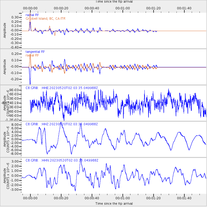
Signal To Noise
| Channel | StoN | STA | LTA |
| C8:GRIB: :HHZ:20230520T02:03:35.049988Z | 8.116182 | 8.473986E-7 | 1.0440852E-7 |
| C8:GRIB: :HHN:20230520T02:03:35.049988Z | 1.9646871 | 2.982756E-7 | 1.5181837E-7 |
| C8:GRIB: :HHE:20230520T02:03:35.049988Z | 1.0650907 | 4.103896E-9 | 3.8530956E-9 |
| Arrivals |
| Ps | 9.6 SECOND |
| PpPs | 30 SECOND |
| PsPs/PpSs | 39 SECOND |


