You are here: Home > Network List > TA - USArray Transportable Network (new EarthScope stations) Stations List
> Station G22A Birney, MT, USA > Earthquake Result Viewer
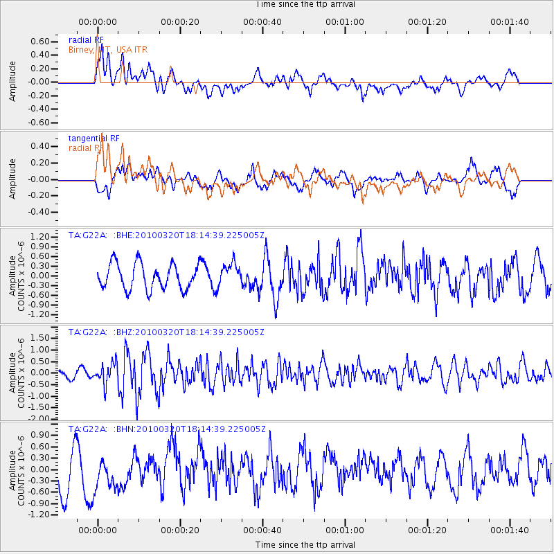
G22A Birney, MT, USA - Earthquake Result Viewer
*The percent match for this event was below the threshold and hence no stack was calculated.
| Earthquake location: |
Cuba Region |
| Earthquake latitude/longitude: |
19.7/-75.3 |
| Earthquake time(UTC): |
2010/03/20 (079) 18:08:08 GMT |
| Earthquake Depth: |
15 km |
| Earthquake Magnitude: |
5.5 MB, 5.4 MS, 5.6 MW, 5.6 MW |
| Earthquake Catalog/Contributor: |
WHDF/NEIC |
|
| Network: |
TA USArray Transportable Network (new EarthScope stations) |
| Station: |
G22A Birney, MT, USA |
| Lat/Lon: |
45.22 N/106.29 W |
| Elevation: |
1203 m |
|
| Distance: |
36.1 deg |
| Az: |
321.905 deg |
| Baz: |
124.654 deg |
| Ray Param: |
$rayparam |
*The percent match for this event was below the threshold and hence was not used in the summary stack. |
|
| Radial Match: |
74.24586 % |
| Radial Bump: |
400 |
| Transverse Match: |
44.14704 % |
| Transverse Bump: |
400 |
| SOD ConfigId: |
308276 |
| Insert Time: |
2010-06-22 22:00:58.465 +0000 |
| GWidth: |
2.5 |
| Max Bumps: |
400 |
| Tol: |
0.001 |
|
Signal To Noise
| Channel | StoN | STA | LTA |
| TA:G22A: :BHZ:20100320T18:14:39.225005Z | 3.005653 | 4.4849622E-7 | 1.4921757E-7 |
| TA:G22A: :BHN:20100320T18:14:39.225005Z | 0.9560612 | 4.373389E-7 | 4.574382E-7 |
| TA:G22A: :BHE:20100320T18:14:39.225005Z | 0.8666241 | 3.406619E-7 | 3.9309074E-7 |
| Arrivals |
| Ps | |
| PpPs | |
| PsPs/PpSs | |


