You are here: Home > Network List > CN - Canadian National Seismograph Network Stations List
> Station DI2B Dawson Inlet, BC, CA > Earthquake Result Viewer
DI2B Dawson Inlet, BC, CA - Earthquake Result Viewer
| Earthquake location: |
Southeast Of Loyalty Islands |
| Earthquake latitude/longitude: |
-23.1/170.4 |
| Earthquake time(UTC): |
2023/05/20 (140) 01:51:01 GMT |
| Earthquake Depth: |
45 km |
| Earthquake Magnitude: |
7.4 Mi |
| Earthquake Catalog/Contributor: |
NEIC PDE/at |
|
| Network: |
CN Canadian National Seismograph Network |
| Station: |
DI2B Dawson Inlet, BC, CA |
| Lat/Lon: |
53.20 N/132.48 W |
| Elevation: |
82 m |
|
| Distance: |
90.6 deg |
| Az: |
30.348 deg |
| Baz: |
230.655 deg |
| Ray Param: |
0.04168261 |
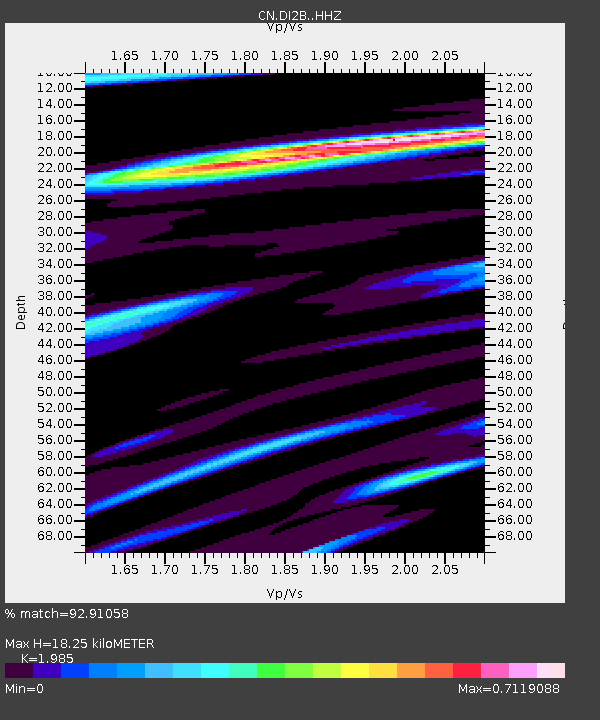
| Estimated Moho Depth: |
18.25 km |
| Estimated Crust Vp/Vs: |
1.99 |
| Assumed Crust Vp: |
6.183 km/s |
| Estimated Crust Vs: |
3.115 km/s |
| Estimated Crust Poisson's Ratio: |
0.33 |
|
| Radial Match: |
92.91058 % |
| Radial Bump: |
400 |
| Transverse Match: |
80.69314 % |
| Transverse Bump: |
400 |
| SOD ConfigId: |
30536071 |
| Insert Time: |
2023-06-03 02:06:27.256 +0000 |
| GWidth: |
2.5 |
| Max Bumps: |
400 |
| Tol: |
0.001 |
|

Signal To Noise
| Channel | StoN | STA | LTA |
| CN:DI2B: :HHZ:20230520T02:03:27.369995Z | 8.2448845 | 1.2428417E-6 | 1.5074096E-7 |
| CN:DI2B: :HHN:20230520T02:03:27.369995Z | 2.2945764 | 2.4340108E-7 | 1.0607669E-7 |
| CN:DI2B: :HHE:20230520T02:03:27.369995Z | 1.4358214 | 2.2039514E-7 | 1.534976E-7 |
| Arrivals |
| Ps | 3.0 SECOND |
| PpPs | 8.7 SECOND |
| PsPs/PpSs | 12 SECOND |


