You are here: Home > Network List > TA - USArray Transportable Network (new EarthScope stations) Stations List
> Station M27A Reverse DX Ranch, Oshkosh, NE, USA > Earthquake Result Viewer
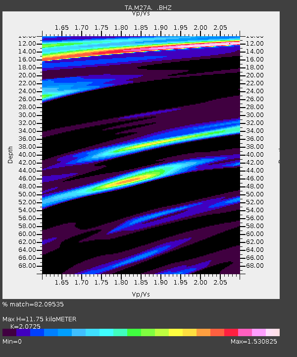
M27A Reverse DX Ranch, Oshkosh, NE, USA - Earthquake Result Viewer
| Earthquake location: |
Cuba Region |
| Earthquake latitude/longitude: |
19.7/-75.3 |
| Earthquake time(UTC): |
2010/03/20 (079) 18:08:08 GMT |
| Earthquake Depth: |
15 km |
| Earthquake Magnitude: |
5.5 MB, 5.4 MS, 5.6 MW, 5.6 MW |
| Earthquake Catalog/Contributor: |
WHDF/NEIC |
|
| Network: |
TA USArray Transportable Network (new EarthScope stations) |
| Station: |
M27A Reverse DX Ranch, Oshkosh, NE, USA |
| Lat/Lon: |
41.53 N/102.39 W |
| Elevation: |
1147 m |
|
| Distance: |
31.7 deg |
| Az: |
319.411 deg |
| Baz: |
125.257 deg |
| Ray Param: |
0.07897226 |
| Estimated Moho Depth: |
11.75 km |
| Estimated Crust Vp/Vs: |
2.07 |
| Assumed Crust Vp: |
6.483 km/s |
| Estimated Crust Vs: |
3.128 km/s |
| Estimated Crust Poisson's Ratio: |
0.35 |
|
| Radial Match: |
82.09535 % |
| Radial Bump: |
400 |
| Transverse Match: |
53.8872 % |
| Transverse Bump: |
400 |
| SOD ConfigId: |
308276 |
| Insert Time: |
2010-06-22 22:01:23.943 +0000 |
| GWidth: |
2.5 |
| Max Bumps: |
400 |
| Tol: |
0.001 |
|

Signal To Noise
| Channel | StoN | STA | LTA |
| TA:M27A: :BHZ:20100320T18:14:00.700011Z | 4.811976 | 5.441878E-7 | 1.13090294E-7 |
| TA:M27A: :BHN:20100320T18:14:00.700011Z | 0.7580833 | 3.118294E-7 | 4.1133927E-7 |
| TA:M27A: :BHE:20100320T18:14:00.700011Z | 0.9182697 | 2.663377E-7 | 2.90043E-7 |
| Arrivals |
| Ps | 2.1 SECOND |
| PpPs | 5.2 SECOND |
| PsPs/PpSs | 7.3 SECOND |


