You are here: Home > Network List > TA - USArray Transportable Network (new EarthScope stations) Stations List
> Station O27A Beecher Island, Eckley, CO, USA > Earthquake Result Viewer
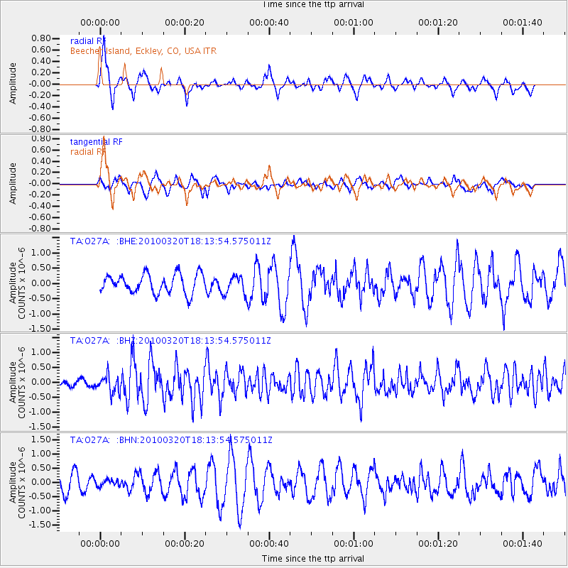
O27A Beecher Island, Eckley, CO, USA - Earthquake Result Viewer
*The percent match for this event was below the threshold and hence no stack was calculated.
| Earthquake location: |
Cuba Region |
| Earthquake latitude/longitude: |
19.7/-75.3 |
| Earthquake time(UTC): |
2010/03/20 (079) 18:08:08 GMT |
| Earthquake Depth: |
15 km |
| Earthquake Magnitude: |
5.5 MB, 5.4 MS, 5.6 MW, 5.6 MW |
| Earthquake Catalog/Contributor: |
WHDF/NEIC |
|
| Network: |
TA USArray Transportable Network (new EarthScope stations) |
| Station: |
O27A Beecher Island, Eckley, CO, USA |
| Lat/Lon: |
40.19 N/102.48 W |
| Elevation: |
1206 m |
|
| Distance: |
31.0 deg |
| Az: |
317.21 deg |
| Baz: |
123.316 deg |
| Ray Param: |
$rayparam |
*The percent match for this event was below the threshold and hence was not used in the summary stack. |
|
| Radial Match: |
74.4652 % |
| Radial Bump: |
400 |
| Transverse Match: |
43.419296 % |
| Transverse Bump: |
352 |
| SOD ConfigId: |
308276 |
| Insert Time: |
2010-06-22 22:01:36.287 +0000 |
| GWidth: |
2.5 |
| Max Bumps: |
400 |
| Tol: |
0.001 |
|
Signal To Noise
| Channel | StoN | STA | LTA |
| TA:O27A: :BHZ:20100320T18:13:54.575011Z | 2.6781588 | 2.912865E-7 | 1.0876372E-7 |
| TA:O27A: :BHN:20100320T18:13:54.575011Z | 0.2693236 | 1.11660725E-7 | 4.145969E-7 |
| TA:O27A: :BHE:20100320T18:13:54.575011Z | 1.0156875 | 3.1577594E-7 | 3.1089874E-7 |
| Arrivals |
| Ps | |
| PpPs | |
| PsPs/PpSs | |


