You are here: Home > Network List > G - GEOSCOPE Stations List
> Station CRZF Port Alfred, Crozet, South Indian Ocean > Earthquake Result Viewer
CRZF Port Alfred, Crozet, South Indian Ocean - Earthquake Result Viewer
| Earthquake location: |
Southeast Of Loyalty Islands |
| Earthquake latitude/longitude: |
-23.1/170.4 |
| Earthquake time(UTC): |
2023/05/20 (140) 01:51:01 GMT |
| Earthquake Depth: |
45 km |
| Earthquake Magnitude: |
7.4 Mi |
| Earthquake Catalog/Contributor: |
NEIC PDE/at |
|
| Network: |
G GEOSCOPE |
| Station: |
CRZF Port Alfred, Crozet, South Indian Ocean |
| Lat/Lon: |
46.43 S/51.86 E |
| Elevation: |
140 m |
|
| Distance: |
91.3 deg |
| Az: |
217.429 deg |
| Baz: |
125.993 deg |
| Ray Param: |
0.041614063 |
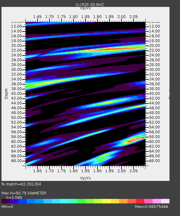
| Estimated Moho Depth: |
58.75 km |
| Estimated Crust Vp/Vs: |
2.07 |
| Assumed Crust Vp: |
4.802 km/s |
| Estimated Crust Vs: |
2.325 km/s |
| Estimated Crust Poisson's Ratio: |
0.35 |
|
| Radial Match: |
82.281204 % |
| Radial Bump: |
400 |
| Transverse Match: |
54.505367 % |
| Transverse Bump: |
400 |
| SOD ConfigId: |
30536071 |
| Insert Time: |
2023-06-03 02:07:44.050 +0000 |
| GWidth: |
2.5 |
| Max Bumps: |
400 |
| Tol: |
0.001 |
|
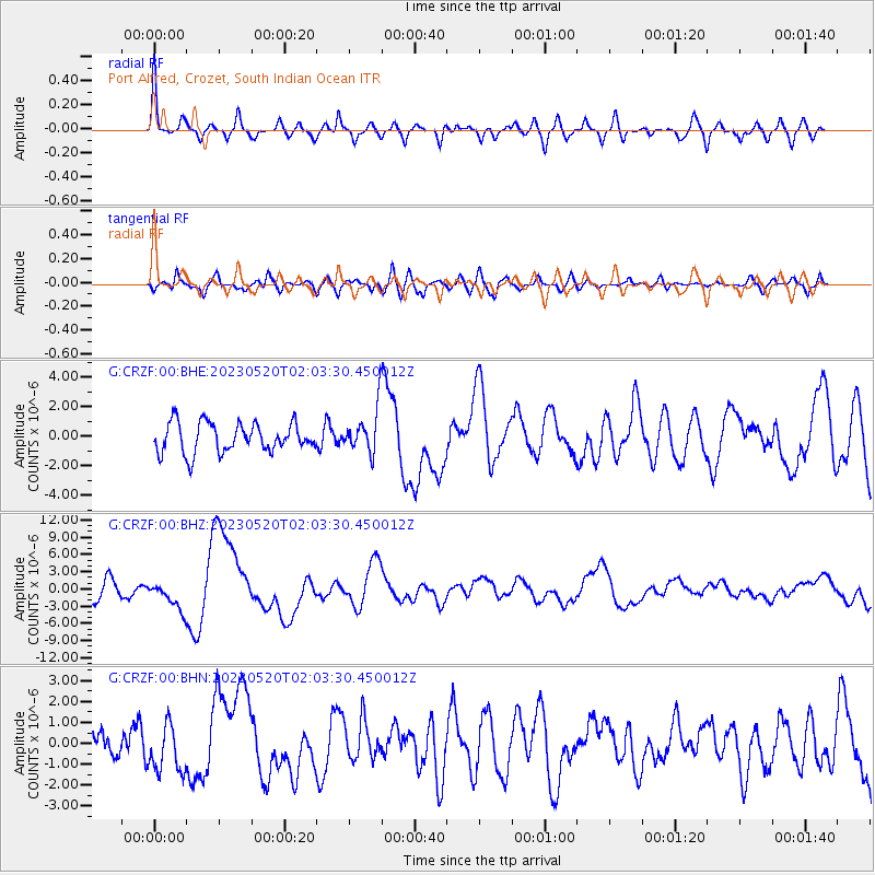
Signal To Noise
| Channel | StoN | STA | LTA |
| G:CRZF:00:BHZ:20230520T02:03:30.450012Z | 2.1358013 | 2.5014474E-6 | 1.1711985E-6 |
| G:CRZF:00:BHN:20230520T02:03:30.450012Z | 0.97550964 | 1.1432502E-6 | 1.1719518E-6 |
| G:CRZF:00:BHE:20230520T02:03:30.450012Z | 1.534882 | 1.5230105E-6 | 9.922655E-7 |
| Arrivals |
| Ps | 13 SECOND |
| PpPs | 37 SECOND |
| PsPs/PpSs | 50 SECOND |


