You are here: Home > Network List > GS - US Geological Survey Networks Stations List
> Station ASA5 ASA5 > Earthquake Result Viewer
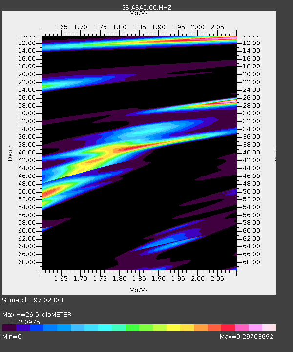
ASA5 ASA5 - Earthquake Result Viewer
| Earthquake location: |
Southeast Of Loyalty Islands |
| Earthquake latitude/longitude: |
-23.1/170.4 |
| Earthquake time(UTC): |
2023/05/20 (140) 01:51:01 GMT |
| Earthquake Depth: |
45 km |
| Earthquake Magnitude: |
7.4 Mi |
| Earthquake Catalog/Contributor: |
NEIC PDE/at |
|
| Network: |
GS US Geological Survey Networks |
| Station: |
ASA5 ASA5 |
| Lat/Lon: |
34.94 N/106.46 W |
| Elevation: |
1835 m |
|
| Distance: |
97.6 deg |
| Az: |
55.371 deg |
| Baz: |
247.258 deg |
| Ray Param: |
0.04014235 |
| Estimated Moho Depth: |
26.5 km |
| Estimated Crust Vp/Vs: |
2.10 |
| Assumed Crust Vp: |
6.502 km/s |
| Estimated Crust Vs: |
3.1 km/s |
| Estimated Crust Poisson's Ratio: |
0.35 |
|
| Radial Match: |
97.02803 % |
| Radial Bump: |
320 |
| Transverse Match: |
88.40479 % |
| Transverse Bump: |
400 |
| SOD ConfigId: |
30536071 |
| Insert Time: |
2023-06-03 02:08:07.050 +0000 |
| GWidth: |
2.5 |
| Max Bumps: |
400 |
| Tol: |
0.001 |
|

Signal To Noise
| Channel | StoN | STA | LTA |
| GS:ASA5:00:HHZ:20230520T02:03:59.078979Z | 6.1807036 | 5.6943173E-7 | 9.213057E-8 |
| GS:ASA5:00:HH1:20230520T02:03:59.078979Z | 1.1642152 | 6.8620466E-8 | 5.8941392E-8 |
| GS:ASA5:00:HH2:20230520T02:03:59.078979Z | 3.4246664 | 1.807783E-7 | 5.2787126E-8 |
| Arrivals |
| Ps | 4.5 SECOND |
| PpPs | 12 SECOND |
| PsPs/PpSs | 17 SECOND |


