You are here: Home > Network List > IW - Intermountain West Stations List
> Station IMW Indian Meadow, Wyoming, USA > Earthquake Result Viewer
IMW Indian Meadow, Wyoming, USA - Earthquake Result Viewer
| Earthquake location: |
Southeast Of Loyalty Islands |
| Earthquake latitude/longitude: |
-23.1/170.4 |
| Earthquake time(UTC): |
2023/05/20 (140) 01:51:01 GMT |
| Earthquake Depth: |
45 km |
| Earthquake Magnitude: |
7.4 Mi |
| Earthquake Catalog/Contributor: |
NEIC PDE/at |
|
| Network: |
IW Intermountain West |
| Station: |
IMW Indian Meadow, Wyoming, USA |
| Lat/Lon: |
43.90 N/110.94 W |
| Elevation: |
2646 m |
|
| Distance: |
98.0 deg |
| Az: |
45.702 deg |
| Baz: |
245.728 deg |
| Ray Param: |
0.040022697 |
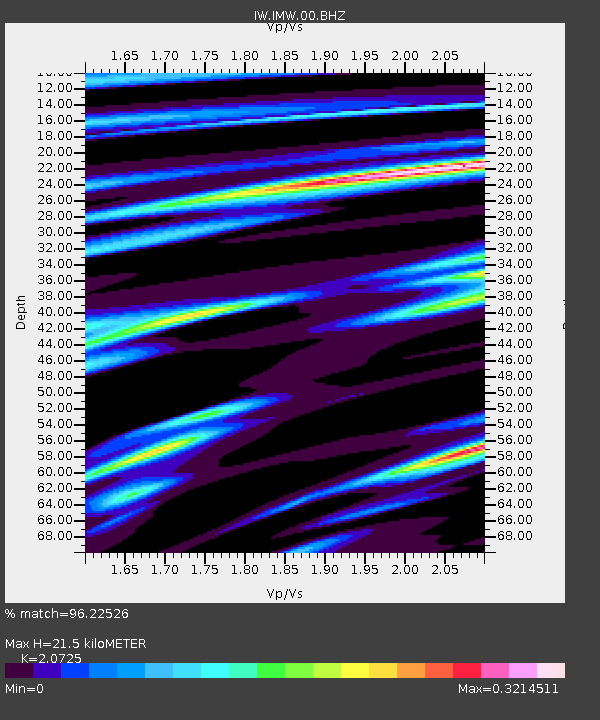
| Estimated Moho Depth: |
21.5 km |
| Estimated Crust Vp/Vs: |
2.07 |
| Assumed Crust Vp: |
6.207 km/s |
| Estimated Crust Vs: |
2.995 km/s |
| Estimated Crust Poisson's Ratio: |
0.35 |
|
| Radial Match: |
96.22526 % |
| Radial Bump: |
334 |
| Transverse Match: |
84.46585 % |
| Transverse Bump: |
400 |
| SOD ConfigId: |
30536071 |
| Insert Time: |
2023-06-03 02:10:01.243 +0000 |
| GWidth: |
2.5 |
| Max Bumps: |
400 |
| Tol: |
0.001 |
|

Signal To Noise
| Channel | StoN | STA | LTA |
| IW:IMW:00:BHZ:20230520T02:04:00.76001Z | 2.7818913 | 2.7476457E-7 | 9.8768986E-8 |
| IW:IMW:00:BH1:20230520T02:04:00.76001Z | 1.7208364 | 1.3992647E-7 | 8.131306E-8 |
| IW:IMW:00:BH2:20230520T02:04:00.76001Z | 1.0305256 | 6.761929E-8 | 6.561632E-8 |
| Arrivals |
| Ps | 3.8 SECOND |
| PpPs | 10 SECOND |
| PsPs/PpSs | 14 SECOND |


