You are here: Home > Network List > MB - Montana Regional Seismic Network Stations List
> Station LIMT Lima, MT > Earthquake Result Viewer
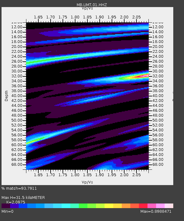
LIMT Lima, MT - Earthquake Result Viewer
| Earthquake location: |
Southeast Of Loyalty Islands |
| Earthquake latitude/longitude: |
-23.1/170.4 |
| Earthquake time(UTC): |
2023/05/20 (140) 01:51:01 GMT |
| Earthquake Depth: |
45 km |
| Earthquake Magnitude: |
7.4 Mi |
| Earthquake Catalog/Contributor: |
NEIC PDE/at |
|
| Network: |
MB Montana Regional Seismic Network |
| Station: |
LIMT Lima, MT |
| Lat/Lon: |
44.62 N/112.64 W |
| Elevation: |
1956 m |
|
| Distance: |
97.2 deg |
| Az: |
44.524 deg |
| Baz: |
244.697 deg |
| Ray Param: |
0.040275235 |
| Estimated Moho Depth: |
31.5 km |
| Estimated Crust Vp/Vs: |
2.10 |
| Assumed Crust Vp: |
6.577 km/s |
| Estimated Crust Vs: |
3.136 km/s |
| Estimated Crust Poisson's Ratio: |
0.35 |
|
| Radial Match: |
93.7911 % |
| Radial Bump: |
371 |
| Transverse Match: |
88.75725 % |
| Transverse Bump: |
400 |
| SOD ConfigId: |
30536071 |
| Insert Time: |
2023-06-03 02:10:45.171 +0000 |
| GWidth: |
2.5 |
| Max Bumps: |
400 |
| Tol: |
0.001 |
|

Signal To Noise
| Channel | StoN | STA | LTA |
| MB:LIMT:01:HHZ:20230520T02:03:57.159973Z | 7.4600067 | 9.0039214E-7 | 1.2069589E-7 |
| MB:LIMT:01:HHN:20230520T02:03:57.159973Z | 1.5108631 | 3.7161885E-7 | 2.459646E-7 |
| MB:LIMT:01:HHE:20230520T02:03:57.159973Z | 1.0776228 | 2.1070217E-7 | 1.9552498E-7 |
| Arrivals |
| Ps | 5.3 SECOND |
| PpPs | 15 SECOND |
| PsPs/PpSs | 20 SECOND |


