You are here: Home > Network List > TX - Texas Seismological Network Stations List
> Station PB28 Culberson South > Earthquake Result Viewer
PB28 Culberson South - Earthquake Result Viewer
| Earthquake location: |
Southeast Of Loyalty Islands |
| Earthquake latitude/longitude: |
-23.1/170.4 |
| Earthquake time(UTC): |
2023/05/20 (140) 01:51:01 GMT |
| Earthquake Depth: |
45 km |
| Earthquake Magnitude: |
7.4 Mi |
| Earthquake Catalog/Contributor: |
NEIC PDE/at |
|
| Network: |
TX Texas Seismological Network |
| Station: |
PB28 Culberson South |
| Lat/Lon: |
31.67 N/104.50 W |
| Elevation: |
1204 m |
|
| Distance: |
97.9 deg |
| Az: |
59.049 deg |
| Baz: |
247.835 deg |
| Ray Param: |
0.040058102 |
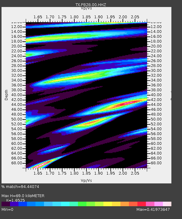
| Estimated Moho Depth: |
69.0 km |
| Estimated Crust Vp/Vs: |
1.65 |
| Assumed Crust Vp: |
6.361 km/s |
| Estimated Crust Vs: |
3.849 km/s |
| Estimated Crust Poisson's Ratio: |
0.21 |
|
| Radial Match: |
94.44074 % |
| Radial Bump: |
400 |
| Transverse Match: |
79.78726 % |
| Transverse Bump: |
400 |
| SOD ConfigId: |
30536071 |
| Insert Time: |
2023-06-03 02:14:51.413 +0000 |
| GWidth: |
2.5 |
| Max Bumps: |
400 |
| Tol: |
0.001 |
|

Signal To Noise
| Channel | StoN | STA | LTA |
| TX:PB28:00:HHZ:20230520T02:04:00.27002Z | 3.695007 | 2.4308636E-7 | 6.5787795E-8 |
| TX:PB28:00:HH1:20230520T02:04:00.27002Z | 0.91530395 | 5.812339E-8 | 6.350174E-8 |
| TX:PB28:00:HH2:20230520T02:04:00.27002Z | 0.9250257 | 6.9162446E-8 | 7.476814E-8 |
| Arrivals |
| Ps | 7.2 SECOND |
| PpPs | 28 SECOND |
| PsPs/PpSs | 35 SECOND |


